WaWaRu – Forest structure, water balance and shallow landslides
2019 - 2034
Cooperation FinancingThe quantification of forests' impact on soil and slope stability poses a considerable challenge to the scientific community and ultimately to practitioners. The WaWaRu project marks a key step towards understanding the processes involving different forest structures and helps overcome this challenge. As part of the project, various forest structures are studied in field experiments with regard to the groundwater balance, which is the main trigger for shallow landslides. The project adopts a multi-method approach in areas around Davos where there is a high risk of shallow landslides. To help meet our goal of providing forest management with practical support, we are working closely with the Rhaetian Railway, the Grisons Office for Forestry and Natural Hazards as well as the Davos Forestry Service.

Along with avalanches, rockfall and debris flows, landslides are among the most significant alpine mass movements. Almost half of Switzerland's forest is protection forest, meaning that it protects citizens from alpine mass movements and consequently reduces the risk to people and infrastructure. Just over a quarter of this protection forest is dedicated to protecting against shallow landslides. The influence of vegetation, and especially that of the forest, on soil and slope stability is a key component of a comprehensive strategy to protect against natural hazards. Protection forest is often more environmentally friendly, cost efficient and sustainable than technical control structures. However, sustainable, long-term forest management (protection forest maintenance) is crucial to maintaining a forest's protective function.

To support forest management, research findings must be implemented with variables that are as easy to collect as possible while remaining of practical relevance. On the one hand, at present there is often very little room for manoeuvre in practice between economic efficiency and the sustainable preservation of the protective function of the forest. On the other, sufficient, comprehensive quantification of the impact of vegetation still poses a major challenge for research.
The results of the SOSTANAH project (NFP 68) made it clear that forest structure plays an important role here: diversity both above and below ground as well as the coexistence of different succession and development stages boost a stock's resilience and adaptability. As a result, multi-layered forest stands comprising a varied mix of tree species and a diverse age structure, a sufficient degree of crown cover and small gap lengths in the slope line are significantly more efficient in protecting against shallow landslides than single-layered forest stands with a homogeneous age structure and comprising one tree species.

The WaWaRu project helps provide a better understanding of the impact of different forest structures on the groundwater balance (the main trigger for shallow landslides) and therefore focuses on the interaction between forest structure, soil hydrology and evapotranspiration.
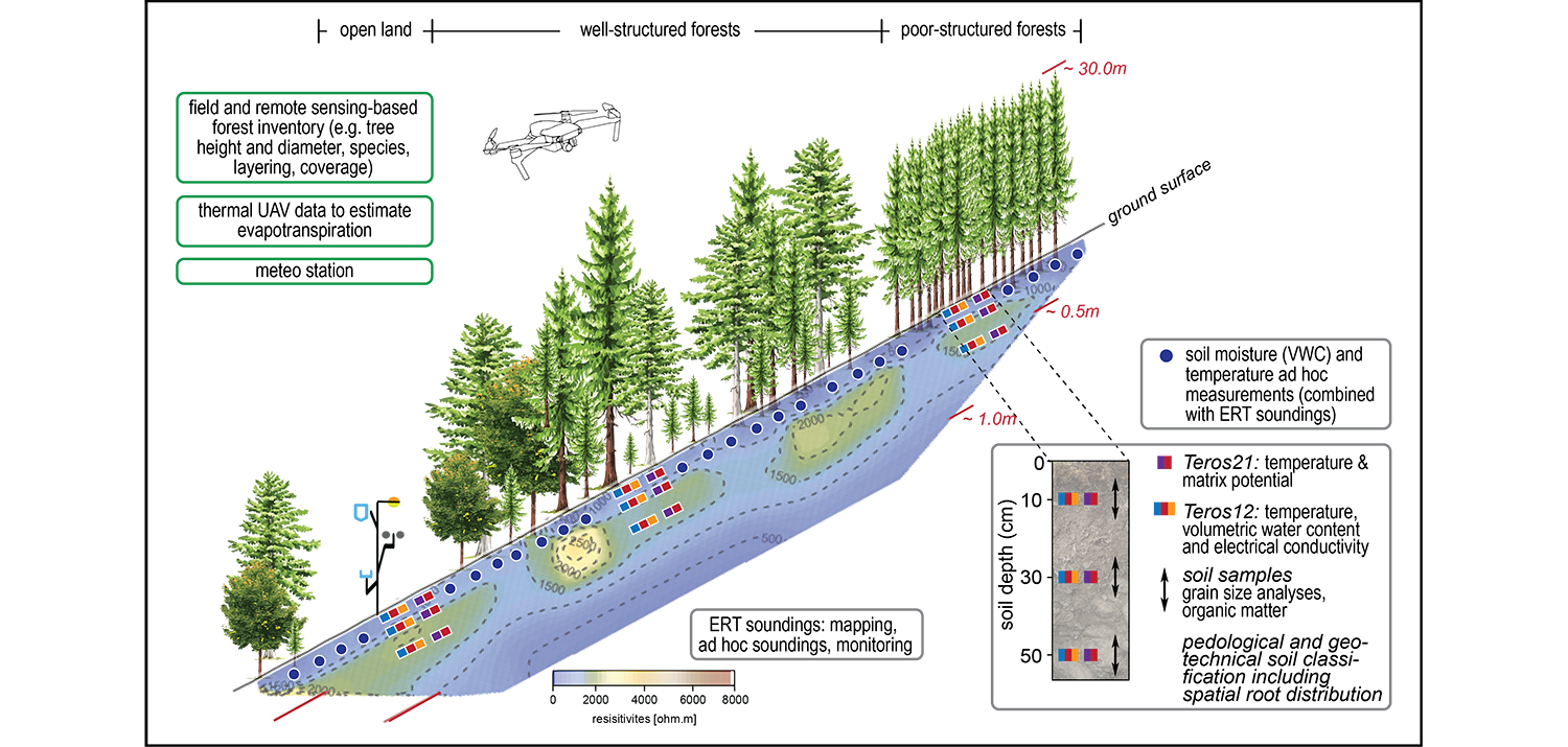
At certain potential 'landslide hotspots' around Davos, researchers measure the volumetric water content, temperature, matrix potential and electrical conductivity and record the results several times a day at different soil depths in relatively 'well' and 'poorly' structured forest stands, as well as in regeneration plots planned for later. Electrical resistance tomography (ERT) is also used to record the relative change in moisture in the soil after precipitation events along a two-dimensional section in the subsoil. Thermal data are collected concurrently with the ERT soundings via drone in order to estimate evapotranspiration. Furthermore, a geotechnical and pedological profile is created of the soil based on individual profiles. The forest and terrain are also characterised and classified according to conventional standards, such as the forest stand code. A climate station records air temperature, humidity, precipitation, radiation as well as wind speed and direction.
(Kopie 6)
The WaWaRu project, together with the projects SlimForest (Shallow landslides: impact of forest structure on slope stability) and WHFF (Do well-structured and well-maintained forests offer better protection? Interactive maps on the impact against shallow landslides), provides a key piece of the puzzle when it comes to understanding different forest structures and ultimately helps ensure enhanced quantification of the impact of forests on soil and slope stability.
WaWaRu not only contributes to scientific (process) understanding but also ultimately aims to provide practical support for forest management. To guarantee an application-oriented focus and ensure that the research findings are put into practice, we work closely with our project partners, namely the Rhaetian Railway, the Grisons Office for Forestry and Natural Hazards and the Davos Forestry Service.