

Site description 
Contents 
Location and catchment characteristics 
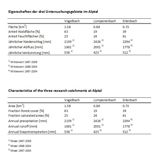
The Alptal (Canton Schwyz) is a 42 km2 catchment located in the Swiss pre-Alps about 30 km southeast of Zurich. The altitude of the Alptal valley ranges from 840 m a.s.l. at the outflow of the catchment (Einsiedeln) to the top of the Grossen Mythen at 1899 m a.s.l. The topography of the Alptal is rather flat, but the slopes are steep (20 to 40o). The geological parent material is flysch, consisting of calcareous sandstones with argillite and bentonite shales. Most of the area is covered by gley soils with low permeability, resulting in high water tables and limited deep percolation in much of the area. The forest is a subalpine spruce forest with sporadic maple and beech in the lower areas. The open areas are partially grazed and partially left to natural reforestation.
The side streams of the Alptal valley are steep torrents with a step-pool morphology; the main stream at the bottom of the valley (Alp) has a much lower gradient (40 to 60 m/km). The streams respond very quickly to precipitation. Runoff in torrents can vary over four to five orders of magnitude, with half of the total runoff leaving the watershed within 7 to 10% of the time. The runoff response of the Alp at Einsiedeln is also quite rapid and differs only slightly compared to the torrents - despite the nearly 50-fold difference in catchment size.
Meteorological characteristics 
The area has one of the highest precipitation levels in Switzerland. The annual precipitation shows an increase from north to south, averaging 1723 mm/year at the MeteoSchweiz station in Einsiedeln (911 m a.s.l.) and 2266 mm/year at the Erlenhöhe meteorological station (1210 m a.s.l.). There is also an altitudinal gradient in mean annual air temperature, from 6.7 °C in Einsiedeln to 5.7 °C at Erlenhöhe. A continuous snow cover of up to 2 m thickness usually forms from December to April, but at lower elevations (< 1300 m a.s.l.) rain also falls regularly in winter, which can lead to intermittent snow-free periods.
Hydrometeorological longterm measurements and infrastructure 
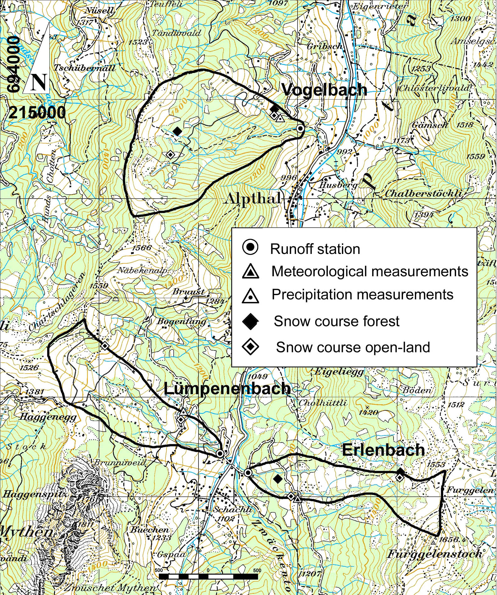
The Swiss Federal Institute for Forest, Snow and Landscape Research WSL has been measuring discharge in three small torrent catchments since 1968: Erlenbach, Lümpenenbach and Vogelbach. The stations are maintained and cleaned weekly and after major storm events. The level-discharge relationship of the three stations has changed occasionally due to reconstruction or natural changes in headwater conditions and is updated regularly. Detailed information on the sensors is currently being prepared and will be provided here shortly.
Comprehensive measurements of bedload transport are made at the Erlenbach station (see detailed information). In addition, the water quality in the three torrents has been measured for many years. For this purpose, water is continuously collected at the stations and pumped into a refrigerator. Once a week the collected water is sent to EAWAG for chemical analysis. The chemical measurements are part of the National River Monitoring and Survey Programme (NADUF).
Since 1981, a meteorological station at the Erlenhöhe site (1210 m a.s.l.) has recorded air temperature and humidity, wind speed and direction, and global radiation. Precipitation is measured with a heated tipping bucket as well as with a totalizer. In addition, all four components of the radiation balance have been measured since 2003 (sensor specifications and manufacturers will be made available here shortly).
Precipitation is also measured near the runoff stations Lümpenenbach (since 1986) and Vogelbach (since 1985), as well as in the village of Alpthal (since 1974) and at the monastery of Einsiedeln. The Alpthal and Einsiedeln rain gauges are currently operated by MeteoSwiss.
Snow depth and snow water equivalent (SWE) have been measured manually along 20- to 30-m transects at about 15 sites in the Alptal since 1968. These transects represent different elevations, exposures, and land uses (open meadows and closed forests). A detailed description of the snow measurements can be found in Stähli and Gustafsson (2006).
Additional specific hydrological measurements 
In addition to the longterm measurements, there are a large number of specific measurements in the Alptal - installed and operated by various institutions. These are described under the "current research projects".