16.07.2020 | Beate Kittl/LSCE (CNRS/CEA/UVSQ) | News WSL
An international consortium of scientists has refined the map of caesium and plutonium radionuclide concentrations in soils in Switzerland and several neighbouring countries. Using an archive of European soil samples, the team led by Katrin Meusburger from the University of Basel, now at the WSL research institute, was able to trace the sources of radioactive fallout between 1960 and 2009. This study was published in Scientific Reports.
The new map comprises Switzerland as well as several neighbouring countries (France, Italy, Germany, Belgium). It is based on a new calculation method, namely the use of the caesium/plutonium ratio. These two radionuclides were released during military nuclear tests, particularly in the 1960s, but caesium also during the Chernobyl accident in 1986.
"We have created a new map to provide a basis for estimating the soil loss since the anthropogenic release of radionuclides," says first author Katrin Meusburger from the group Environmental Geocience at the University of Basel, who is now working at the Swiss Federal Institute for Forest, Snow and Landscape Research WSL. "To do this, it is important to know the proportion of radioactive fallout from Chernobyl."
The data collected, made available to the scientific community and the public, are useful for establishing a reference base in the event of possible future fallout of radionuclides, but also for use in new studies, particularly in geomorphology. They will, for example, allow the reconstruction of soil erosion rates since the 1960s in areas of Europe where there have been major landscape changes.
Higher accuracy and resolution 
The consortium researchers used 160 samples from a European soil sample bank from 2009. These samples were taken from soils under grassland, which have remained stable since the 1960s (absence of erosion and accumulation) and are representative of the variability of rainfall conditions observed in the countries covered by the study.
The radionuclides found in these samples, caesium and plutonium (137Cs, 239Pu, 240Pu), left a specific footprint in European soils. Indeed, in the countries covered by the study, the plutonium came exclusively from the nuclear tests. As for caesium, it is the result of both nuclear tests, particularly in the 1960s, and the 1986 Chernobyl accident. The relationship between cesium and plutonium is therefore different depending on whether it comes from nuclear tests or from the Chernobyl accident. It is this relationship that has enabled researchers to trace the origin of these artificial radionuclides deposited on European soils. "Unlike with the previous map, we can now distinguish between the sources of nuclear fallout," says Meusburger.
The study concludes that the caesium resulting from the nuclear tests - carried out in the stratosphere, i.e. at high altitude - circulated in the atmosphere before being brought down to the ground by the rains in a fairly homogeneous manner but with a slightly higher amounts in the rainiest regions, such as the Massif Central, the Ardennes or Brittany. On the other hand, the caesium released during the Chernobyl accident did not reach such altitudes; it remained at tropospheric level. The scattered rains that occurred in late April/early May 1986 quickly brought it back to the ground in areas where the plume from Ukraine had circulated. The spatial distribution of radioactive fallout is thus much more heterogeneous, with locally higher concentrations in Alsace, Franche-Comté and the foothills of the Alps, northern Italy and southern Germany.
* The consortium consisted of geomorphologists, soil scientists and geochemists from the University of Basel (Switzerland) and the Swiss Federal Institute for Forest, Snow and Landscape Research (WSL), as well as the Fonds de la Recherche Scientifique (FNRS, Belgium), the Laboratoire des Sciences du Climat et de l’Environnement (LSCE - CEA/CNRS/UVSQ, France), the Joint Research Centre of the European Commission (Ispra, Italy), the Metropolitan State University of Denver (Colorado, USA) and the joint FAO/IAEA Division of Nuclear Techniques in Food and Agriculture (Austria).
Original text by the Laboratoire des Sciences du Climat et de l’Environnement (LSCE - CEA/CNRS/UVSQ , Institut Pierre Simon Laplace, Université Paris-Saclay) (Link)

Image 1 of 4
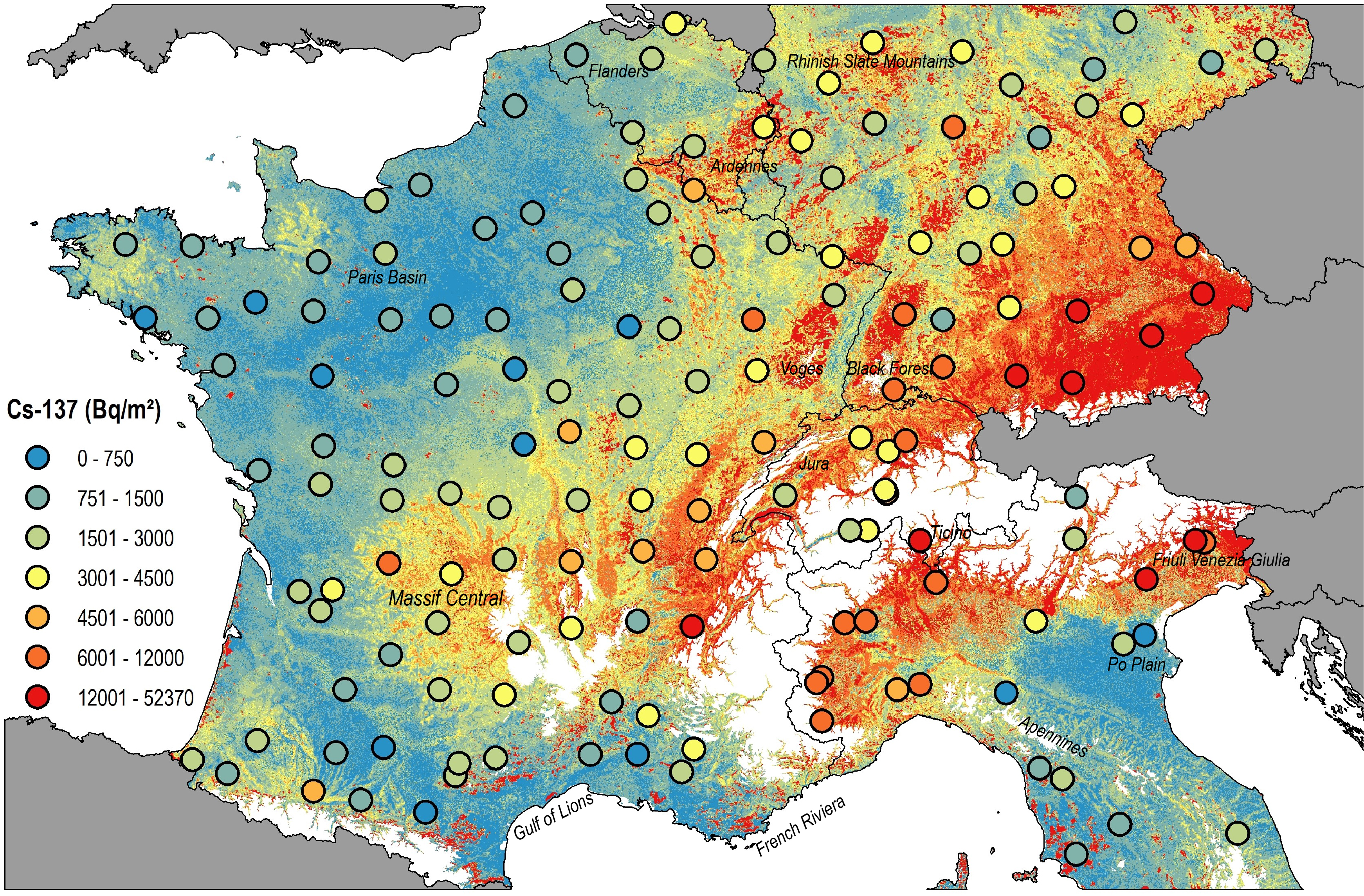
Baseline inventories of Caesium 137 (0-20 cm) topsoil (Bq m-2) - corrected for radioactive decay as of August 1, 2009, estimated using a generalized additive model with 500 m resolution. In the study area, areas above 1000 m were masked out (white). © Scientific Reports

Image 2 of 4
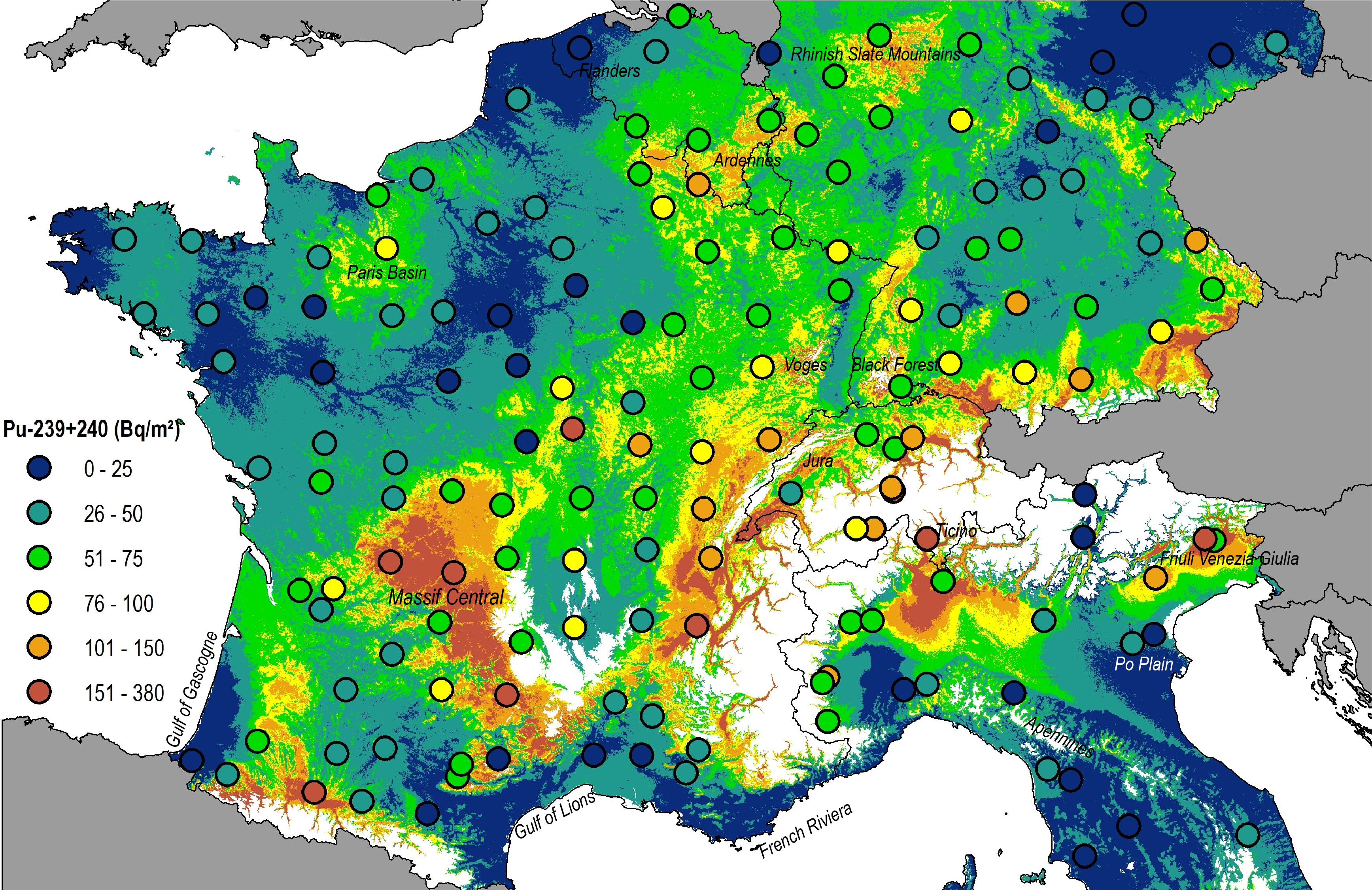
Baseline inventories of Plutonium 239+240 in the topsoil (0-20 cm) (Bq m-2) are estimated with an additive model with a resolution of 500 m. In the study area, areas above 1000 m elevation were masked out (white). © Scientific Reports

Image 3 of 4
Comparison of the gain in spatial resolution obtained by this method (left: 1997 map; right: new 2009 map produced by this study). © Scientific Reports

Image 4 of 4
A. Contribution of Caesium 137 fallout from Chernobyl as % of soil samples (0-20cm) - corrected for radioactive decay to 2009.
Areas above 1000 m altitude were masked out (white).
B. Origin of Caesium 137 (PBq) from grassland in Western Europe. © Scientific Reports
Contact 
Links 
Katrin Meusburger, Olivier Evrard, Christine Alewell, Pasquale Borrelli, Giorgia Cinelli, Michael Ketterer, Lionel Mabit, Panos Panagos, Kristof van Oost, Cristiano Ballabio (2020): Plutonium aided reconstruction of caesium atmospheric fallout in European topsoils. Scientific Reports, https://www.nature.com/articles/s41598-020-68736-2
Copyright 
WSL and SLF provide the artwork for imaging of press articles relating to this media release for free. Transferring and saving the images in image databases and saving of images by third parties is not allowed.