

AquaREL allows you to explore how aquatic ecosystems will be affected by climate change in Switzerland. Will water runoff and quality change in certain regions? How are nutrient and sediment loads be affected?
Available indicators in the app 
Water runoff 
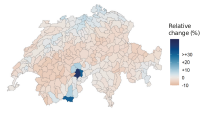
The app shows how the average annual water runoff in a region is changing. The maps provide indications of possible long-term changes in water availability in certain regions and are suitable for the rough classification of regional trends, for example with regard to increasing water scarcity. However, they do not replace detailed analyses of seasonal fluctuations or extreme events that are particularly relevant for water management.
Nutrient load 
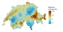
The app shows how nutrient inputs (nitrogen and phosphorus) change under different climate scenarios. The modeled nutrient discharge is influenced by annual precipitation amounts. Since the models are based on annual values, seasonal variability is not reflected. The indicator serves to raise awareness of possible long-term developments and can be used as a supplementary basis for overarching planning issues, such as nutrient retention.
Sediment load 
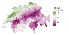
The indicator illustrates how sediment loads washed out of the soil into water bodies change under different climate scenarios. These data provide information on areas with increased erosion and sediment dynamics and can serve as a basis for the further development of land use and management practices.
Publications 
Contact 
Cécilia Barouillet, Anthony Lehmann (University of Geneva)
Ces travaux ont été soutenus par le National Centre for Climate Services NCCS et réalisés dans le cadre du programme «Bases décisionnelles pour faire face au changement climatique en Suisse (NCCS-Impacts)» qui fait partie du projet «Effets du changement climatique sur les services écosystémiques».