Piz Buin Pitschen: Experimental investigations
Yves Bühler, Gregor Ortner, Andreas Stoffel, Robert Kenner, Perry Bartelt, Jessica Munch
2020 - 2030
Piz Buin Pitschen rock slope instability 
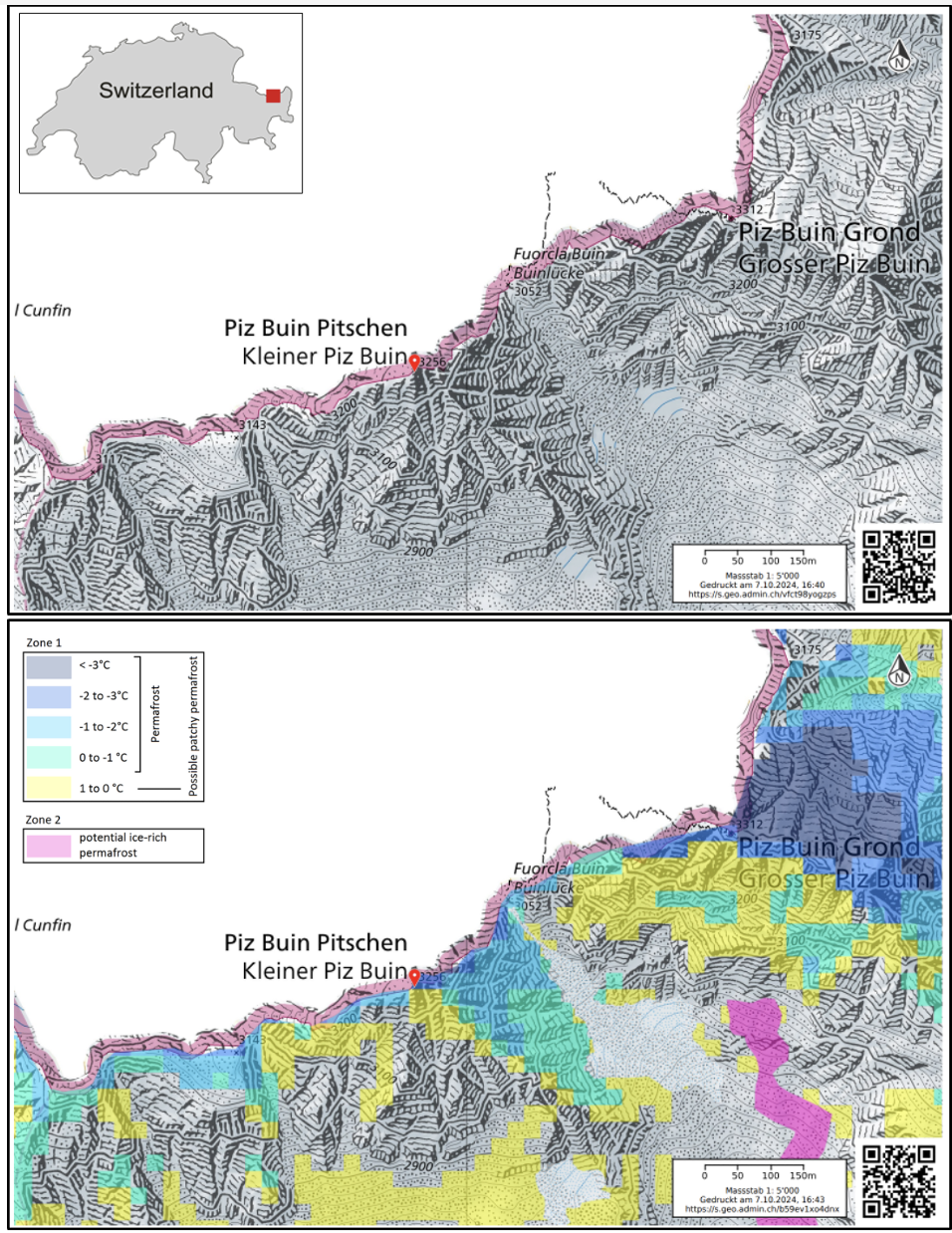
Areas at high elevations are sensitive to the warmer temperatures of the last years, in particular when the permafrost warms. Therefore, rockfalls, rockslides, debris flows and other gravitational mass movement processes are expected to increase in intensity and frequency. However, forecasting magnitude, location, and timing of catastrophic failure events is very difficult. Early identification and monitoring such slope processes is one of the research focuses of the newly created research center CERC (Climate Change, Extremes and Natural Hazards in Alpine Regions Research Centre) at SLF. Currently, CERC Scientists are monitoring an instability at the Piz Buin Pitschen, identified during a field inspection in July 2020. A strongly fractured and deformed rock mass with a crown fracture near the summit of Piz Buin Pitschen was observed. A possible release could cause potential hazards. Indeed, the popular alpinistic route to the Grossen Piz Buin (3’312 m a.s.l.) in the Silvretta Range starts on the Austrian side and leads over the Ochsentaler Glacier passing close to the Kleiner Piz Buin (Piz Buin Pitschen, 3’255 m a.sl.).
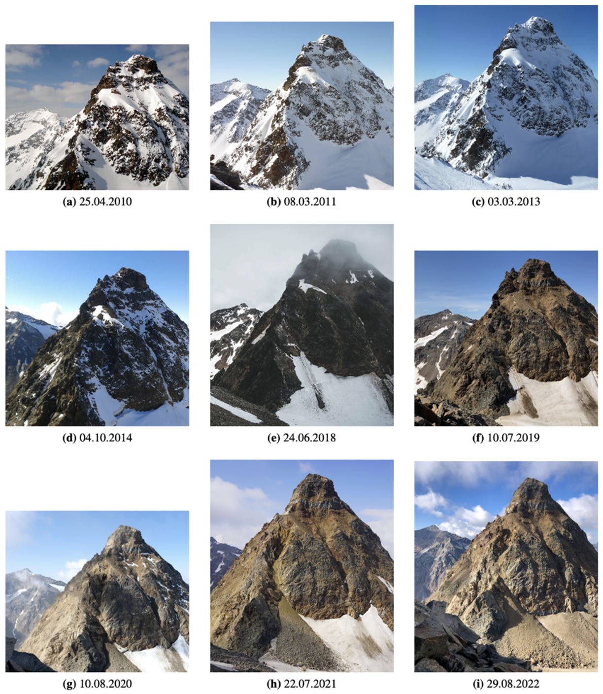
Surface changes from historical photography and crowdsourced images 
The Federal Office of Topography, swisstopo, in the framework of the project “SWISSIMAGE Journey through time” provides historical aerial photographs since 1946 and orthophotos since 1978. CERC scientists acquired and analyzed all the available aerial photos to identify changes on the Piz Buin Pitschen. Initial changes can be seen already in 2005, with an increase of rock fall deposits beneath the northern rock face. The accumulation of debris material in the gully Fuorcla Buin can already be detected in the orthophotos acquired in 2008. In addition to the aerial photos, due to the prominence of the route to Piz Buin numerous pictures and videos can be found in the internet and social media, showing insights into different conditions of the rock mass at different times. These pictures show a strong increase in accumulation in 2019, associated with major rockfall activity.
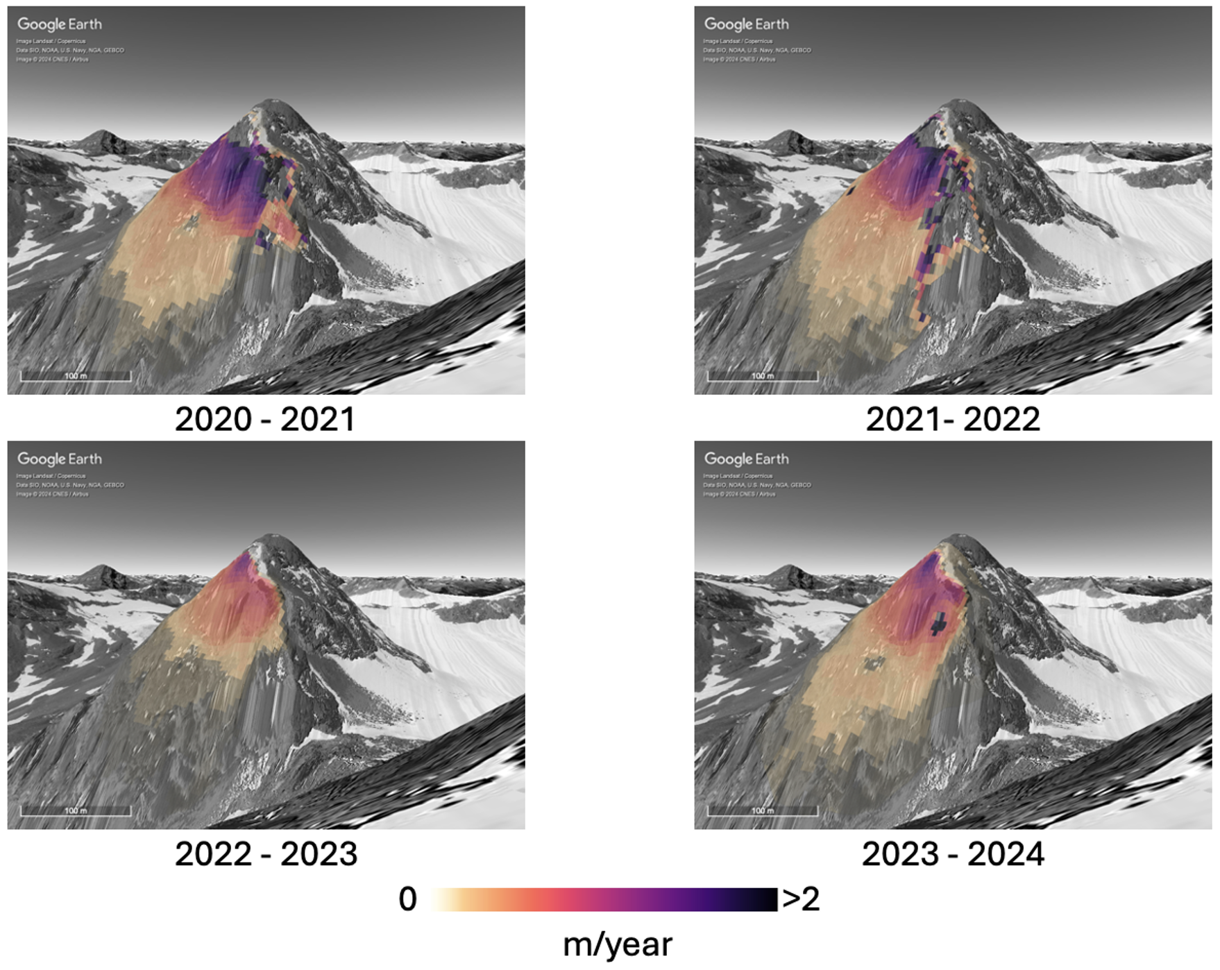
Drone-based surveys 
Since August 2020, drone-based photogrammetric surveys are carried out every summer to update orthophotos and digital elevation models (DEMs). The debris accumulation at the foot of the Piz Buin Pitschen has grown every year. Volume loss due to glacier retreat and slope failures has been computed by calculating the difference between multitemporal DEMs, while surface velocities are measured with digital image correlation methods. Some portions of the Piz Buin Pitschen experienced strong elevation changes due to rock slope failure activity, and surface velocities recorded near the crest are up to 2 m/year. The current results suggest steady slope movements since 2020, with only a slight decrease in 2023. No large deviations or escalations in the rate of displacement were recently detected. It is important to note that the absence of strong acceleration does not diminish the significance of the current state. The cumulative displacements over the last years are significant of attention. Indeed, long term sustained rates of movement in rock slopes in the order of meters/year progressively reduce the rock mass strength and deserve ongoing vigilance as they can cause progressive disintegration of the slope with increase of rock fall activity, and potentially leading to large failures.
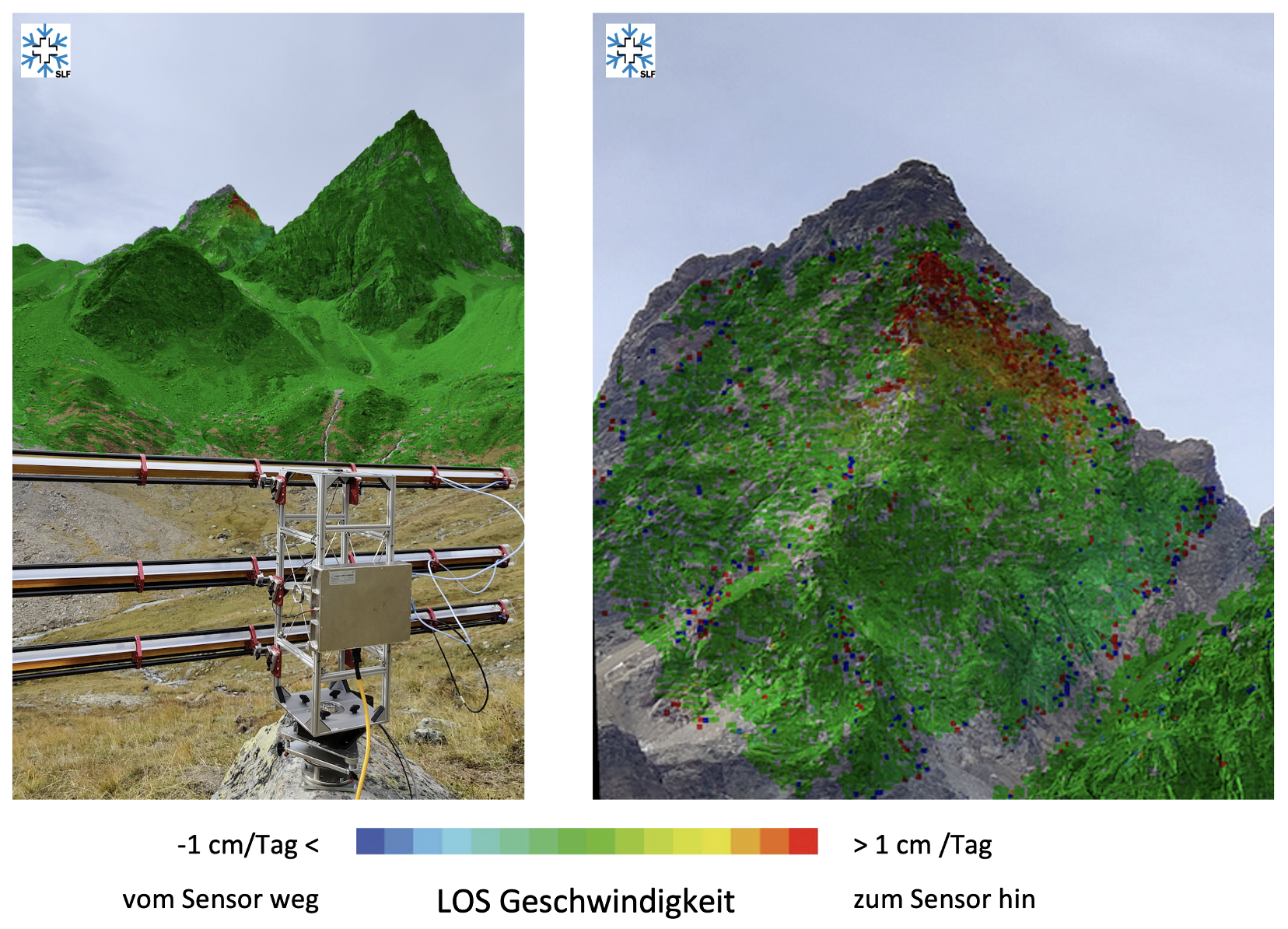
Velocity monitoring with ground-based radar 
On September 13, 2022, in collaboration with GAMMA Remote Sensing AG, a measurement campaign was carried out above Chamonna Tuoi Hutte with a ground-based radar (GAMMA Portable Radar Interferometer, GPRI). Radar images were taken every ca. 5 minutes between September 13, 2:30 p.m. and September 14, 9.00 a.m. on, for a total of 448 acquisitions. These measurements confirm the results obtained with the drone-based surveys, showing velocities up to 1 cm/day in the upper portions of the slope.
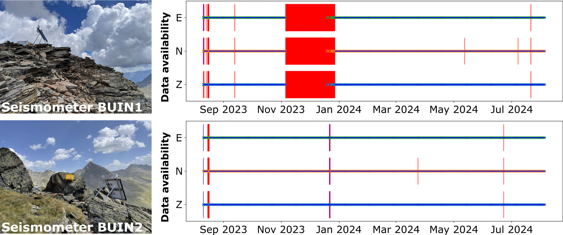
Seismic monitoring for rockfall detection and structural characterization 
In August 2023, we deployed two seismometer stations to complement yearly remote sensing observations with continuous in-situ measurements. These data allow, on the one hand, the detection and characterization of rockfall events throughout the year and, on the other hand, the analysis of ambient seismic vibrations that arise from natural sources such as the world’s oceans, earthquakes, or water fluxes but also from human activity.
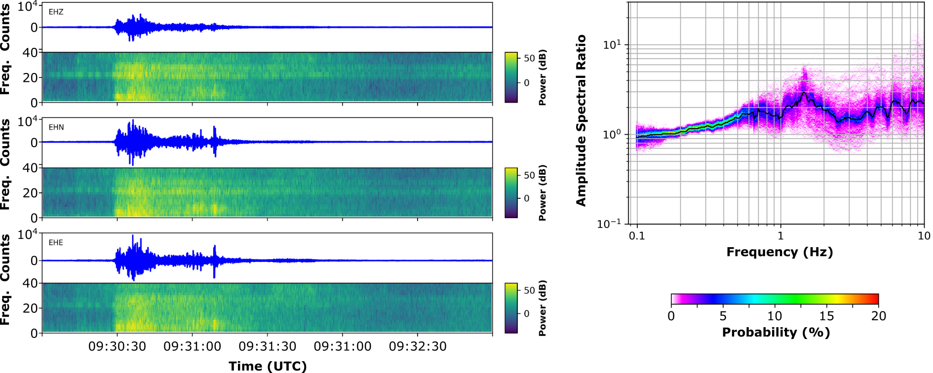
Seismic events were recorded throughout the year with a slightly increased rate from July to September. Although the origin of these seismic events can vary, the seismic response to an observed rockfall event is shown in Figure below. As an alternative and complementary analysis approach, the seismic ambient vibration technique provides information on the structural integrity of rock slopes. In the context of earthquake-induced damage or even earthquake-triggered rock slope failures, this approach enables the quantification of the seismic amplification due to site and topographic effects and can, in combination with data on environmental conditions, provide information about critical constellations (e.g., temperature, water availability by rain or snowmelt and earthquake).
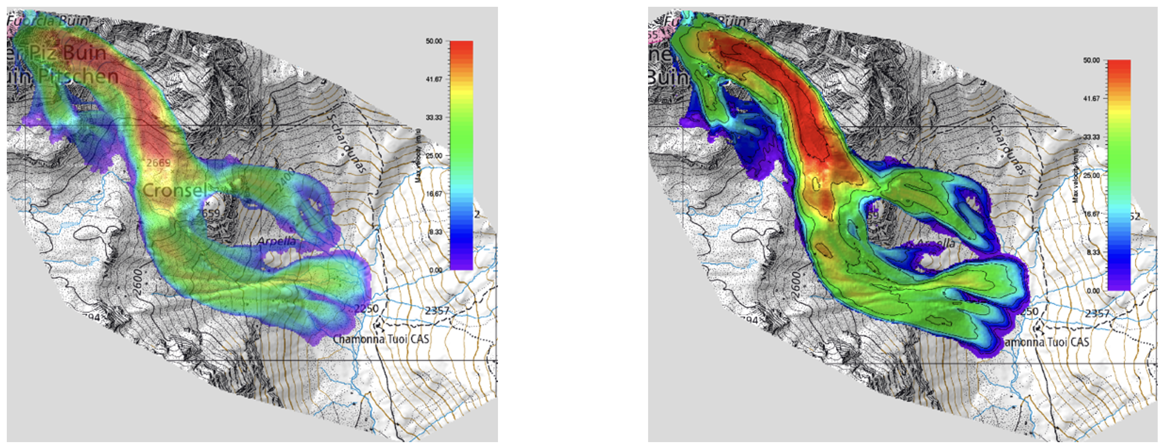
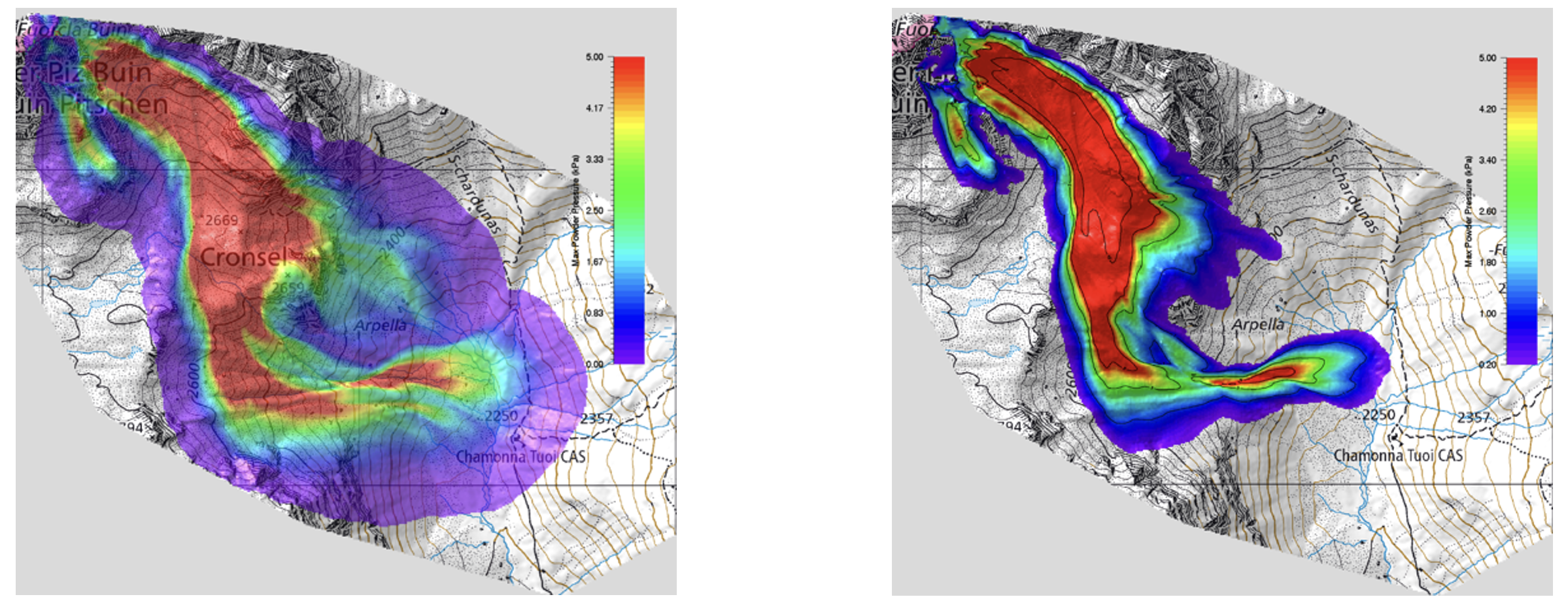
Geological modeling and potential failure scenarios 
After evaluation of the DEMs, orthophotos, and structural setting of the rock mass, geologic modeling was performed to provide estimates of the possible release volume in case of slope failure. Simulations with these volumes were performed using RAMMS (Rapid Mass Movement Simulation), to gain first insights on the hazard potential. The calculations were carried out using the newly developed rock/ice module, allowing for the simulation of mixed flow forms (rock/ice/snow), thus estimating the influence during the event of any free water that may be present. Different failure scenarios were computed, such as mass release in winter conditions, i.e., with the presence and entrainment of snow, or in the summer season, i.e., with saturated or dry conditions of the entrainment zone. Moreover, the powder cloud and associated pressures generated by the modeled slope failures have been computed in all cases. If the rock avalanche is able to overflow the terrace at Cronsel, there is considerable danger from the dust cloud. Computed pressures of the dust in the vicinity of the hut is up to 3kPa. Similar pressures were caused in the past injuries to people in high mountain regions. Moreover, it must be assumed that the dust cloud carries smaller stones at high speed and could damage the hut and potentially also kill people.