
Regeneration assessment in open forest areas (CATReg)
Alexander Bast
Peter Bebi
Martina Hobi
Mauro Marty
Petia Simeonova Nikolova
2021 - 2022
Finanzierung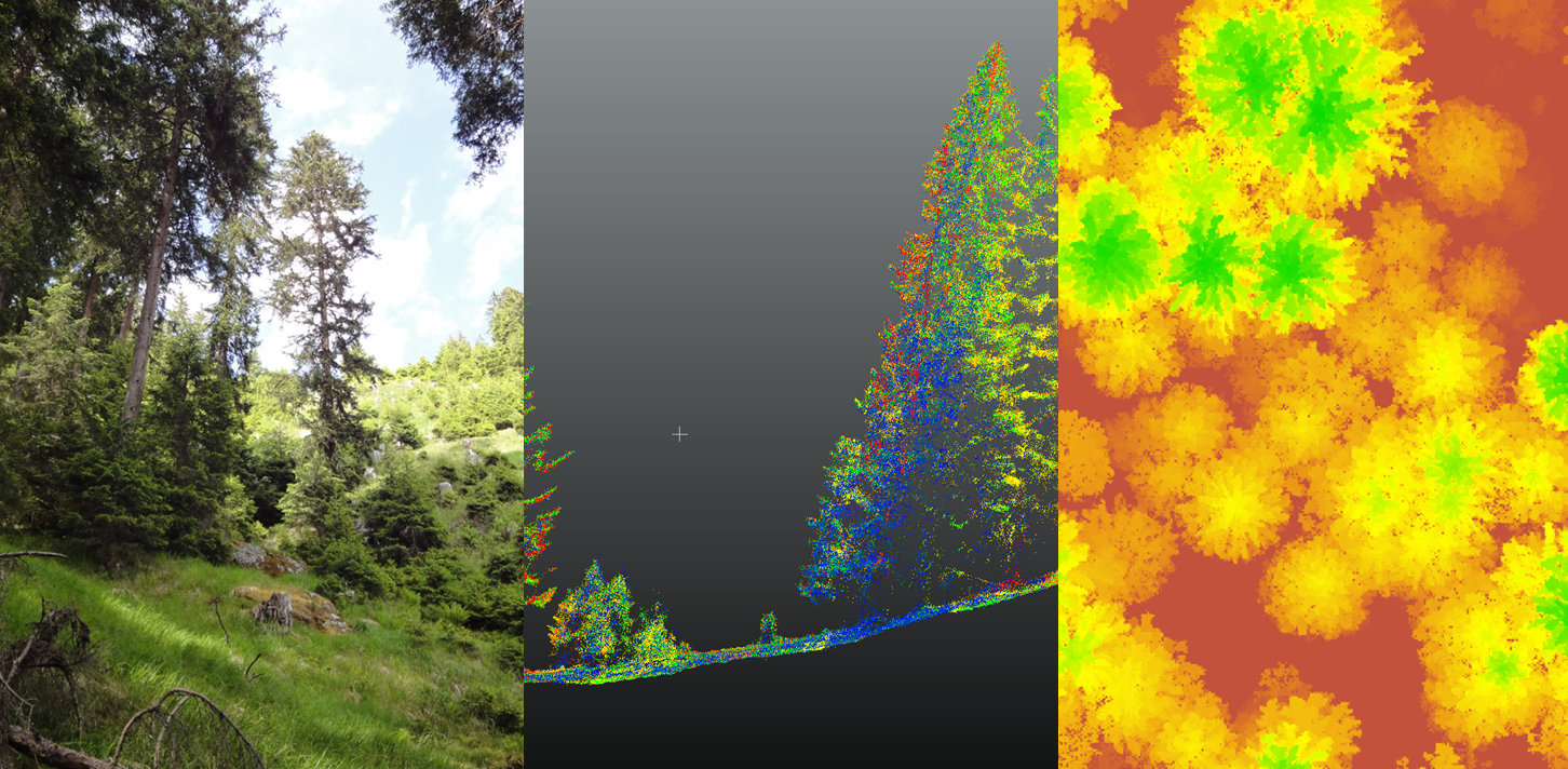
An Unmanned Aerial Vehicle UAV equipped with a LiDAR sensor (Light Detection and Ranging) will be used to test its potential for regeneration structure assessments in mountain forests. A robust detection of the regeneration dynamics is needed to evaluate the silvicultural success. However, common terrestrial methods are time consuming and often fail in assessing regeneration structure adequately as seedlings often occur clustered. The use of LiDAR promises an efficient tool for assessing the regeneration structure in space and time. CATReg aims to combine terrestrial regeneration mapping with LiDAR-based information to assess size, density and location of regeneration.
In the Swiss Alps, one of the main silvicultural goals is to assure a permanent forest cover by continuous renewal of the stands. In high-elevation forests, regeneration is often scarce due to unfavorable microsites, dense overstory or browsing of ungulates. Insufficient regeneration may lead to losses of forest ecosystem services like the protective function against alpine mass movements. Therefore, precise methods are needed to quantify the spatio-temporal regeneration dynamics in an efficient way. While common terrestrial survey methods based on statistical sampling designs yield unbiased estimates of means and variations, they are unsatisfactory if the regeneration is very patchy and diverse. Neglecting this spatial variability may lead to erroneous conclusions about regeneration success. These irregular structural patterns call for additional information on where and in which size classes the natural regeneration occurs in a spatially continuous way.
Research with terrestrial LiDAR data (TLS) has already shown the high potential of high resolution point clouds to estimate and quantify natural forest regeneration. However, the workload for the acquisition of TLS data is very high since the target area needs to be covered with scans from different angles, directions and positions. In contrast, UAV LiDAR allows acquiring data of small objects in mountain forests more efficiently and faster and is better suited to capture small-scale heterogeneity. Therefore, the elaboration of such an innovative method is also of interest for forest practitioners as an efficient tool for estimating regeneration success and its dynamics on a large scale.
CATReg aims
(1) to test the potential of UAV LiDAR based technologies to assess key structural parameters of forest regeneration in training areas, and
(2) to develop an approach for modelling and mapping the spatial distribution of the assessed parameters.
Our approach integrates UAV LiDAR data (RIEGL miniVUX-®2UAV, Austria) with commonly used terrestrial measurements (Fig. 1). The data will be collected in the Swiss Alps during Summer 2021 in two strip cuts (approx. 50 m x 200 m) with known regeneration success and in two plantations (step 1). Due to the high-resolution information of the used sensor (>100 returns per m2), 3D point clouds of vegetation will be used to detect individual saplings and to define their height as well as their horizontal crown projection, and to map their position (step 2). In addition, the cover of regeneration clusters will be detected, classified in size classes, and mapped (step 2). Field surveys of the same parameters will be conducted in the training areas (step 3) to verify and validate the UAV LiDAR results (step 4). Regeneration success will be classified according to the targets defined for individual plants or for plant clusters.

Figure 1: Overview of the methodological steps: 1) Collection of UAV LiDAR data in the training areas; 2) detection and mapping of individual saplings and plant clusters; 3) collection of field plot data in the training areas; 4) validation of the UAV LiDAR results. 1Example of point clouds describing vertical regeneration structures (Puliti et al., 2019).
We expect that we will be able to map individual saplings and plant clusters in regeneration size classes, as well other vegetation. In addition, links between sapling stem density and plant cluster density will be tested in a spatially continuous way. The repeated collection of LiDAR data will include seasonal and inter-annual scales into the analyses, to identify temporal variation in estimates of regeneration data.
Publication 
Puliti S, Solberg S, Granhus A (2019) Use of UAV Photogrammetric Data for Estimation of Biophysical Properties in Forest Stands Under Regeneration. Remote Sensing 11: 233. doi: 10.3390/rs11030233 (Graphical abstract)