Virtuelle Landschaftsrekonstruktion mittels historischen Fotografien 
Seit der Erfindung der Fotografie zu Beginn des neunzehnten Jahrhunderts hat man sich dieser Technik bedient, um alle sichtbaren Dinge des täglichen Lebens festzuhalten und für spätere Zeiten zu dokumentieren. Mit dem Fortschritt der Technik ist man von der Fotografie zur Photogrammetrie übergegangen, die es ermöglicht, nach alten Fotografien Vermessungen und Kartenwerke anzufertigen. Hierzu mussten die Landschaftsfotos allerdings als stereoskopisches Bildpaar vorliegen und man musste sowohl den exakten Punkt kennen, von dem die Fotografie aufgenommen wurde, als auch die optische Geometrie der Kamera.
Durch den Einsatz von Flugzeugen und später von Satelliten ist die Technik der fotogrammetrischen Abbildungen nach alten Landschaftsfotos eindeutig in den Hintergrund gerückt. Dank der jetzt verfügbaren hocheffizienten modernen Informatiksysteme und der immer präziseren digitalen Bodenmodelle gibt es heute neue Möglichkeiten, selbst einzelne alte Landschaftsfotos für eine quantitative Rekonstruktion der Landschaftsentwicklung heranzuziehen (Monophotogrammetrie, Monoplotting). Praktisch bedeutet dies, dass man auf der Grundlage der Kenntnis der technischen Charakteristiken des Fotoapparats, der Rekonstruktion der Position des Fotografen zum Zeitpunkt der Aufnahme und eines Höhenmodells des Gebietes ein Bezugssystem schafft, das anhand einzelner Fotos präzise kartografische Vermessungen möglich macht.
An der WSL haben wir eine neue Monoplotting-Schnittstelle (MPT) entwickelt mit dem Ziel, eine intuitive Plattform für die Georeferenzierung und Orthorektifizierung gewöhnlicher einzelner Schrägaufnahmen anzubieten. Die daraus resultierenden kalibrierten Bilder erlauben es dem Benutzer, georeferenzierte Vektordaten zu erzeugen, indem er sie direkt auf die Bilder zeichnet und mit herkömmlichen GIS-Systemen austauscht. Daraus resultierende Polygone können auf terrestrischen Bildern (Abb. 1) oder Orthofotos und Karten visualisiert werden. Ebenso können aktuelle geografische Elemente auf historische Bilder projiziert werden.
Zudem bietet die vorliegende Monoplotting-Version 2.0 dank der Mitarbeit und der finanziellen Unterstützung des BAFU eine Schnittstelle zur Plattform StorMe 3.0 (Siehe unten, sowei auch BAFU-Seite Naturereigniskataster), um die Beschreibung und Dokumentation von Naturgefahrenereignissen zu erleichtern.

Bild 1 von 5
Abb. 1: Wenn man die Ablichtung einer alten Postkarte mit der Darstellung der Brücke von Melide und Bissone zu Beginn des 20. Jahrhunderts sorgfältig analysiert, kann man mit unterschiedlicher Sicherheit (grün: sehr wahrscheinlich, rot: nicht sehr wahrscheinlich) zahlreiche halbnatürliche Rinnen erkennen.

Bild 2 von 5
Abb. 2: Die Rinnen wurden für die Holzabfuhr genutzt und im Volksmund «óva», «tracióo» «tröcc», «vandüll» oder «vestacc» genannt werden. Mit der neuen Software können diese Kanäle auf dem historischen Foto erkannt, kartografisch erfasst und danach punktgenau auf eine 1:10’000-Karte übertragen werden.

Bild 3 von 5
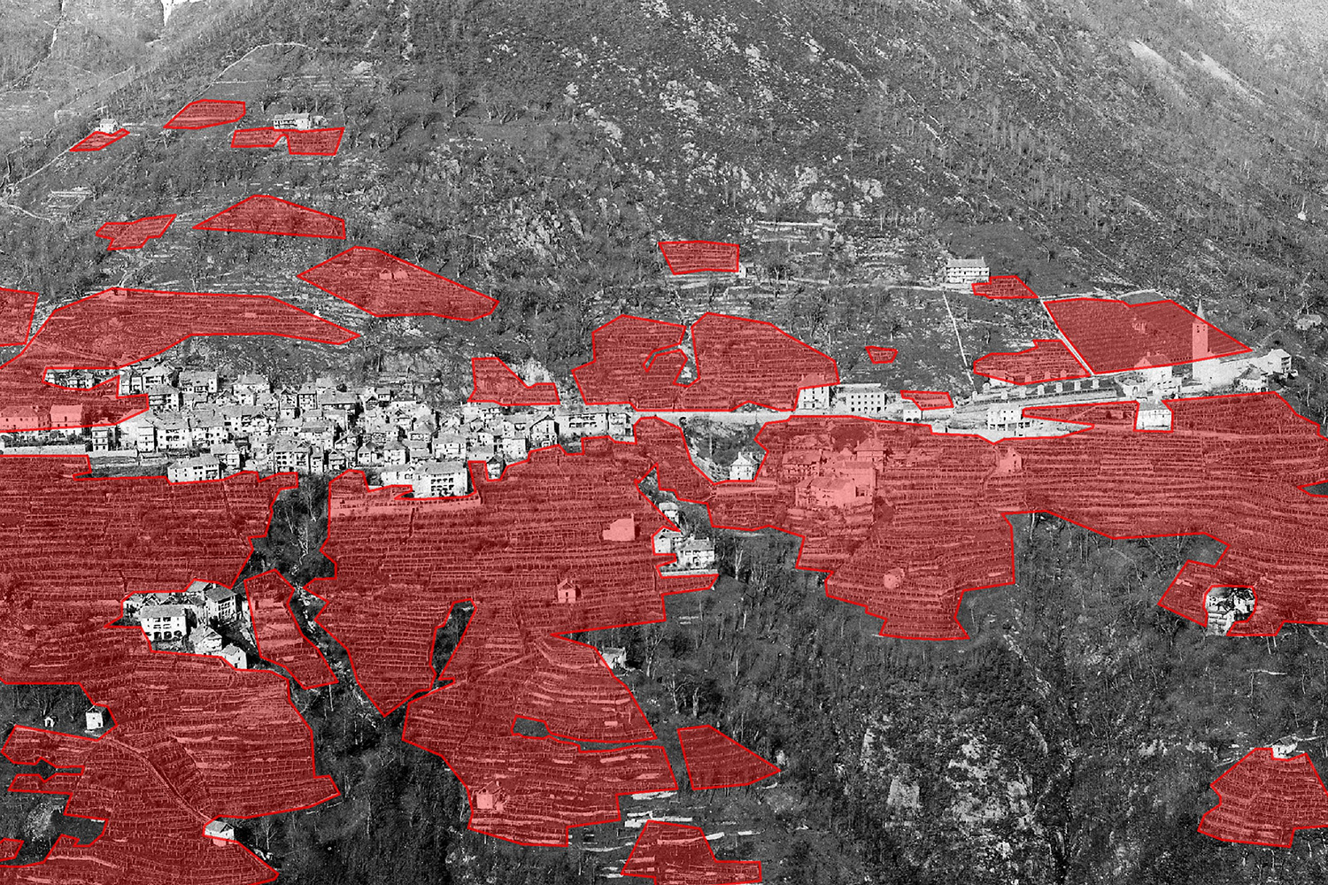
Abb. 4: Die Weinberge um Loco 1885, direkt auf dem historischen Foto digitalisiert, mit der neuen Monophotogrammetie-Software georeferenziert ...

Bild 4 von 5
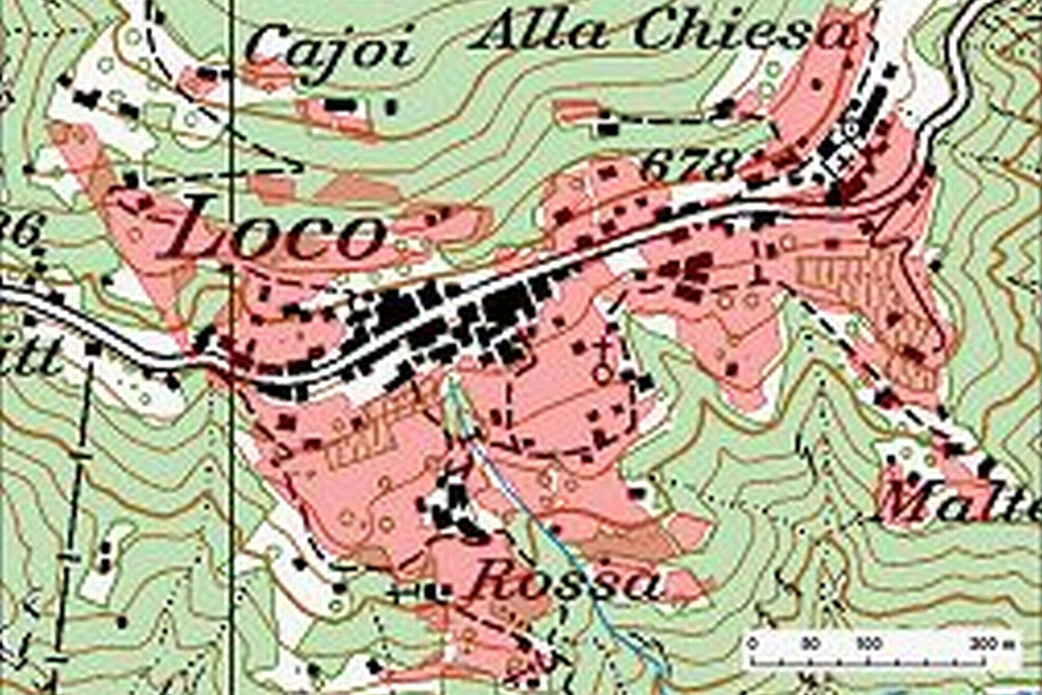
Abb. 5: ... und danach auf eine Landkarte übertragen.

Bild 5 von 5
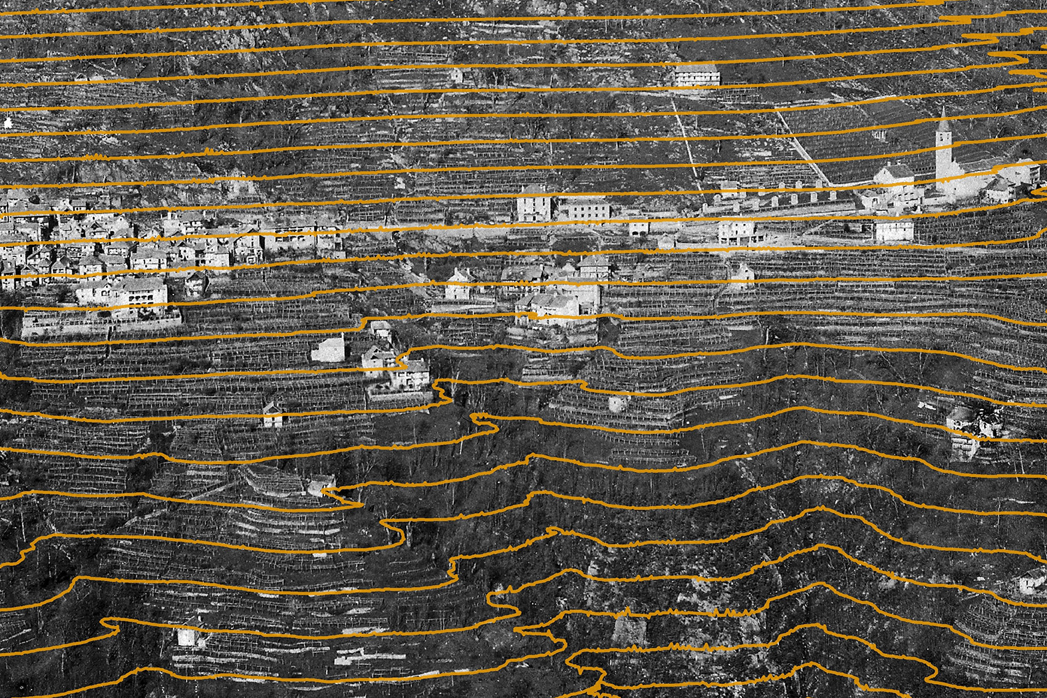
Abb. 3: Mit der neuen Software kann man auf jede Fotografie beliebige georeferenzierte vektorielle Objekte übertragen; in diesem Fall Höhenlinien mit einem Abstand von 10 Metern auf einem historischen Foto von Loco (Val Onsernone) aus dem Jahr 1885.
StorMe 3.0 
Links 
MPT 1.5.4 
-
Monoplotting Setup 1.5.4 41 MB
-
ReleaseNotes154 45 KB
MPT 2.0 
Kontakte 
Publikationen 
Fischer, R.; Bozzini, C., 2013: Fotos wie Karten lesen. Horizonte – Das Schweizer Forschungsmagazin Nr. 96, März 2013 (pdf)
Fischer, R.; Bozzini, C., 2013: Lire les photos comme des cartes. Horizons - Le magazine suisse de la recherche scientifique no 96, Mars 2013 (pdf)
Wiesmann, S.; Steiner, L.; Pozzi, M.; Bozzini, C.; Hurni, L., 2012: Reconstructing Historic Glacier States Based on Terrestrial Oblique Photograph.AutoCarto International Symposium on Automated Cartography, Columbus, Ohio, USA, 16-18 September 2012 (pdf)
Publikationen 
Related work by users
- A century of landscape change in the southern Rocky Mountains and Foothills of Alberta: Using historical photography to quantify ecological change by Christopher Alec Stockdale (PhD thesis)
- Assessment of the viability of worldwide application of the WSL Monoplotting Tool in reconstruction of past glacier stands by Iris Hansche (bachelor thesis)
Nutzungsbedingungen 
The WSL Monoplotting Tool is shareware. It may be used and redistributed freely for non-profit purposes, as long as no modifications are done to the original distribution package. The author retains the copyright of the software.
If you choose to use the program, please provide us with
- your name and e-mail address
- the name of your organisation, if applicable
- a short description of the project are using the program for
Please send this, as well as any questions, remarks and comments to the address below. In return we will keep you informed on updates and any news on the subject.
If you write scientific articles including results obtained using the WSL Monoplotting tool, you must include a proper citation. Because the status of our own publication will change with time, the proper citation must be checked when your article is submitted or resubmitted after revision.
For more informations see the user guide (.zip)