Enhanced understanding of Alpine mass movements Gathered through machine LEarning (EAGLE)
2023 - 2027
Kooperation FinanzierungInhaltsverzeichnis
Enhanced understanding of Alpine mass movements Gathered through machine LEarning
Slow moving alpine mass movements can result in sudden, potentially catastrophic slope failures. The detection and monitoring of such ongoing processes is crucial in alpine regions as they can endanger human lives and cause substantial economic losses. However, field-based mapping and monitoring of such processes is often not economically feasible at a regional level and in many scenarios does not allow to capture the full picture of ongoing processes.
With the advent of spaceborne Differential Interferometric Synthetic Aperture Radars (D-InSAR) it has technically become possible to monitor ground movement across entire mountain ranges. D-InSAR allows exploiting the phase difference between two images to create surface velocity maps, featuring velocities between cm/a to mm/a in the line-of-sight direction seen from the satellite. An ever-increasing number of such satellites orbits the Earth. These are constantly acquiring Earth Observation (EO) images, thereby covering more regions in shorter amount of time and from different viewing angles. While the amount of EO data to be processed has, as a result, become too large to be handled manually, the interpretation of interferometric data still requires extensive human involvement, especially in highly dynamic environments such as geologically young mountain ranges.
The project EAGLE (Enhanced understanding of Alpine mass movements Gathered through machine LEarning) aims at:
- Developing automated strategies to generate homogenous inventories of unstable alpine slopes.
- Developing automated strategies and tools to map surface deformation associated with unstable slopes.
- Providing enhanced information on relevant infrastructures that may be at risk due to slope movements.
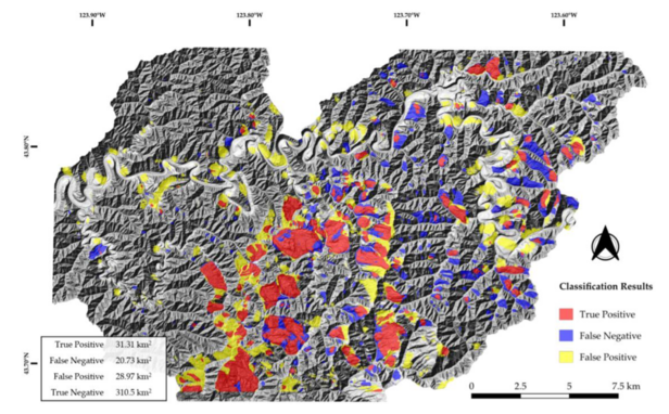
These new methods are required to efficiently exploit the globally available EO data. Recent advances in the field of machine learning skyrocketed the applicability of corresponding algorithms in geosciences. Convolutional Neural Networks (CNN) for example, allow replicating human interpretation of an image without the need for specific feature definition. With increasing computing power, such networks can be trained more deeply and with more detailed information. The aim is to recognize more complicated landform patterns than was previously possible. Figure 1 shows results from testing this algorithm in the area of Oregon. The algorithms developed in this project are based on globally available data sets, so that the approach is exportable to and applicable on mountain ranges worldwide.
To accomplish these tasks, a multidisciplinary team has been assembled to incorporate expert knowledge across several specialized fields. This team includes experts in the following fields:
- Engineering geology related to mass movement.
- Spaceborne remote sensing applications.
- D-InSAR processing and D-InSAR interpretation.
- Data management, machine learning, AI.
- Statistical EO data evaluation.
- Geography.
- Practical implementation into real-case scenarios.

