Research
15.12.2025
Switch flipped for conditions conducive to fire
Switch flipped for conditions conducive to fire
Dry weather and low humidity are the main drivers of forest fires, with temperature playing a minor role.
read more
Research
10.12.2025
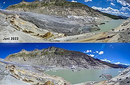
CCAMM: conclusion highlights changing risks
CCAMM: conclusion highlights changing risks
Programme ends: researchers reveal how climate change is altering natural hazards in the Alps – and where action is now required.
read more
Research
08.12.2025
How many insects fly in the sky?
How many insects fly in the sky?
Using radar data, researchers estimate that around 100 trillion insects fly in the air above the USA every day.
read more
Research
26.11.2025
Avalanches sustain glaciers worldwide
Avalanches sustain glaciers worldwide
An international research team shows that avalanches contribute significantly to the health of many glaciers.
read more