

Observing Environmental Changes: Landscape Development and Monitoring 
Here, a hedge is cleared, there, a residential block is built, and over there, a forest encroaches upon the alpine meadows: our environment is changing slowly but steadily. Monitoring programmes are needed in order to gain an overall picture of these (landscape) developments.
Contents 
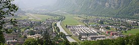
Landscapes change constantly. These changes take place at several spatial scales and at different speeds. Often, they are gradual and are therefore barely noticeable. Since the 1950s, for example, numerous cultural landscapes in the Swiss Plateau which are characterised by agriculture, such as orchards or fields, have been transformed into urban conurbations. We document and quantify such changes and investigate their causes. We collect and analyse the resulting data, reconstruct past developments from it, and use models to calculate possible trends for the future.
Basis for sustainable land use 
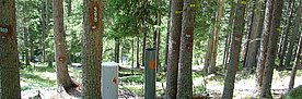
Our research contributes to a sound scientific basis for sustainable land use and landscape development, because decision-makers in the community and government must know how nature and landscape develop in the long term. Where, how fast and why do they change? And what are people saying about it? Environmental monitoring, which also takes social perception into account, is therefore an important basis for decision-making. Thanks to the EnviDat environment database, the data are easily accessible for science and practical use.
We are involved in a number of environmental monitoring programmes, such as the Swiss National Forestry Inventory (LFI) and the Swiss Habitat Protection Impact Monitoring. We lend scientific support to the "Swiss Landscape Monitoring" programme. This programme is the only one of its kind in Europe, because it encompasses both physical landscape development and landscape perception by people. It analyses various aspects and functions of landscapes, such as diversity, nature conservation value and their benefits to society, as well as how people perceive them.
Related topics 
Contact 
Research Units
Research groups