Tessa Hegetschweiler - WML – WaMos meets LFI 
Seit 2014 entwickeln und testen wir verschiedene Ansätze, um das Schweizer soziokulturelle Waldmonitoring WaMos mit dem Landesforstinventar LFI zu verknüpfen. Das LFI bewertet den Wald aus forstwirtschaftlicher und naturwissenschaftlicher Sicht, erfasst aber nicht die Erholungseinstellungen und das Erholungsverhalten der Waldbesucher, während WaMos die soziale Dimension wie die Erholungseinstellungen und das Erholungsverhalten im Wald untersucht, aber keine physischen Daten über den Wald enthält. Insbesondere bei der Walderholung spielen jedoch sowohl die physischen Merkmale des Waldes, in dem die Erholung stattfindet, als auch die sozialen Aspekte wie die Präferenzen und das Verhalten der Besucher eine wichtige Rolle. Es stellt sich die Frage, ob Methoden und Daten aus LFI und WaMos kombiniert werden können, um Erholungsmuster im Wald aus waldbezogenen und besucherbezogenen Daten zu erklären und möglicherweise sogar vorherzusagen. In diesem Vortrag werde ich unsere Forschungen der letzten sechs Jahre zu diesem Thema erläutern, wobei ich mich auf die wahrgenommene visuelle Attraktivität von Wäldern als Indikator für den Erholungswert des Waldes konzentrieren werde. Ich werde unsere verschiedenen Ansätze erläutern, einige wichtige Ergebnisse vorstellen und einen kurzen Ausblick auf künftige Entwicklungen geben.
Dieser Text wurde automatisch übersetzt.
Christian Rosset - TBk: ein Computerprogramm zur Erstellung von Standkarten für praktische Zwecke auf der Grundlage von Fernerkundungsdaten 
TBk ist ein Computerwerkzeug, mit dem auf der Grundlage allgemein zugänglicher Fernerkundungsdaten eine Bestandskarte erstellt werden kann. Die Bestandsabgrenzung basiert auf der räumlichen Verteilung der dominanten Bäume, d.h. der maximalen Höhe pro Flächeneinheit (z.B. Are) eines Vegetationshöhenmodells (VHM-Eingaberaster). Für jeden Bestand werden die dominante Höhe (hdom), die maximale Höhe (hmax) und der Deckungsgrad (DG) bestimmt. Der Abgrenzungsprozess basiert auf einer Reihe von Regeln, die auch für die manuelle Abgrenzung von Beständen im Wald gelten, so dass die Ergebnisse für praktische Zwecke wie Waldbau und Forstplanung nützlich sind. Die Grobheit des resultierenden Bestandesmosaiks kann vom Benutzer mit verschiedenen Parametern eingestellt werden, insbesondere mit dem Toleranzbereich und der Pixelgröße des verwendeten Eingaberasters. TBk wurde an der BFH-HAFL entwickelt und ist in mehreren Kantonen im Einsatz.
Dieser Text wurde automatisch übersetzt.
Daniel Kükenbrink - 3D-Waldstrukturerfassung mit Laserscanning und Photogrammetrie - Möglichkeiten und Grenzen 
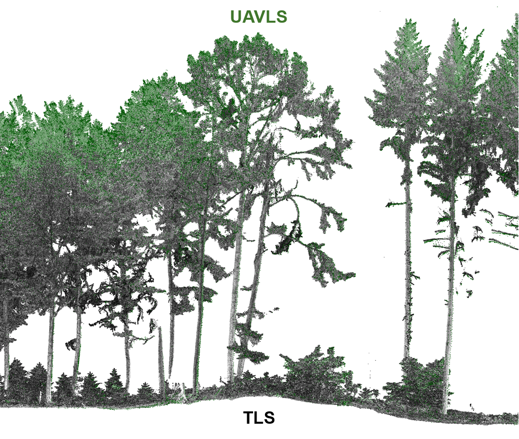
Die Waldstruktur ist ein wichtiger Parameter für die Bewertung der Waldfunktion und -produktivität sowie der Lichtverfügbarkeit im Kronendach des Waldes. Sie gibt uns eine Menge Informationen darüber, wie sich der Wald im Laufe der Zeit entwickelt hat und wie er sich in Zukunft entwickeln wird. Die dreidimensionale Bewertung der Waldstruktur ist jedoch eine nicht triviale Aufgabe. Die jüngsten Fortschritte auf dem Gebiet des Laserscannings und der Photogrammetrie ermöglichen es uns, dreidimensionale Informationen über die Waldstruktur mit immer größerem Detailgrad zu erfassen. In diesem Vortrag werde ich über die jüngsten Erfahrungen berichten, die wir bei der Erprobung neuer Instrumente und Methoden zur Erfassung von 3D-Strukturinformationen auf einer 1 ha großen Versuchsfläche im Ramerenwald neben der WSL in Birmensdorf gemacht haben.
Dieser Text wurde automatisch übersetzt.
Sophia Etzold: Das kontinentale Waldwachstum in Europa wird durch die Bewirtschaftung und die Stickstoffdeposition beeinflusst 
Das Verständnis der Faktoren, die das Waldwachstum antreiben, ist entscheidend für die Vorhersage, wie die Wälder auf den Klimawandel reagieren könnten. Es besteht jedoch Ungewissheit über die Rolle veränderter Umweltfaktoren wie Klima und Luftverschmutzung bei der Beeinflussung der Waldproduktion auf kontinentaler Ebene, insbesondere im Zusammenspiel mit Standort- und Bestandseigenschaften. Wir haben eine kontinentale Analyse der Wachstumsdaten von ICP Forests durchgeführt, die im Zeitraum von 1995 bis 2010 von fast 100 000 Bäumen in 442 Dauerbeobachtungsflächen in gleichaltrigen, bewirtschafteten und fast reinen Waldbeständen in 23 europäischen Ländern gewonnen wurden. Multivariate Statistiken lieferten weitere Belege dafür, dass bewirtschaftungsbezogene Bestandsmerkmale wie der Bestandsdichteindex und das Bestandsalter der Schlüssel zur Erklärung des Waldzuwachses sind. Bei einigen Arten zeigte sich eine eindeutige Beziehung zwischen dem Wachstum und der atmosphärischen N-Deposition, mit einer insgesamt positiven, aber in einigen Fällen nicht linearen Reaktion mit einem Kipppunkt bei 24-34 kg N ha-1 yr-1. Darüber hinaus hatte die N-Deposition indirekt negative Auswirkungen auf den Stammzuwachs, indem sie den pH-Wert des Bodens und die Nährstoffkonzentrationen in den Blättern veränderte. Mit Ausnahme eines konsistenten Temperatursignals für die Fichte zeigten klimabezogene Prädiktoren und bodennahes Ozon weniger verallgemeinerte Beziehungen zum Stammwachstum. Unsere Ergebnisse deuten darauf hin, dass die N-Deposition zusammen mit den treibenden Kräften der Bestandsdichte und des Alters mindestens ebenso wichtig ist wie das Klima, um das Waldwachstum auf kontinentaler Ebene in Europa zu beeinflussen.
Dieser Text wurde automatisch übersetzt.
Lea Flückiger - Einbeziehung von Bodeninformationen in die hochauflösende Verbreitungsmodellierung von Gehölzarten 
Artenverteilungsmodelle (SDMs) liefern Erkenntnisse über die potenzielle Verteilung von Gehölzarten in Abhängigkeit von einer Reihe von Umweltparametern, was für die Entscheidungsfindung in der multifunktionalen Waldbewirtschaftung in der Schweiz von grossem Interesse ist. Es ist bekannt, dass der Boden ein wichtiger Faktor für die Verbreitung von Gehölzarten ist, doch wird er in hochauflösenden SDMs aufgrund der unzureichenden Datenqualität nur am Rande berücksichtigt. Kürzlich wurden im Rahmen eines Forschungsprojekts der Eidgenössischen Forschungsanstalt für Wald, Schnee und Landschaft (WSL) hochauflösende Karten der Bodeneigenschaften für die gesamte Waldfläche der Schweiz mittels digitaler Bodenkartierung (DSM) erstellt. Ziel dieser Arbeit ist es, zu prüfen, ob diese Daten zu einer verbesserten Vorhersagefähigkeit von SDMs für holzige Arten in Schweizer Wäldern führen.
Es wurden zwölf Arten untersucht, von denen sechs empfindlich auf Gradienten der Bodeneigenschaften reagieren sollten und sechs nicht. Für jede Art wurden zwei SDMs für die gesamte bewaldete Fläche der Schweiz erstellt: eines ohne und eines mit Bodendaten. Die Modelle ohne Bodendaten enthielten klimatische, topographische und fernerkundete Bodenparameter, die Modelle mit Bodendaten enthielten zusätzlich Bodenparameter. Die Modelle wurden mit einem Ensemble aus verschiedenen Modellalgorithmen erstellt. Der Einfluss der Bodendaten wurde mit einem Modell mit gemischten Effekten und dem TSS-Modellleistungsmaß, einem Variablenbedeutungstest und einem Variationspartitionierungsansatz getestet. Zusätzlich
Dieser Text wurde automatisch übersetzt.
Martin Sterchi - Query strategies for detection of patient zero 
Infektionskrankheiten verbreiten sich häufig durch Kontakte mit Menschen oder Tieren. In einigen Fällen ist das Netz der Kontakte bekannt (z. B. Tiertransportnetze). Nachdem wir ein infiziertes Individuum zu einem bestimmten Zeitpunkt t beobachtet haben, versuchen wir, eine Wahrscheinlichkeitsverteilung über alle möglichen Quellen (Patient Null) der Krankheitsausbreitung zu finden. Allerdings kann die Wahrscheinlichkeitsverteilung über eine potenziell große Anzahl möglicher Quellen nach der Beobachtung eines einzigen infizierten Individuums recht uninformativ sein. Unser Ziel ist es daher, unbeobachtete Knoten im Netzwerk abzufragen und ihren Infektionsstatus zu erfahren, um so viele Informationen wie möglich über die Quelle der Ausbreitung zu erhalten. Zu diesem Zweck nutzen wir Ideen aus dem Konzeptlernen und dem aktiven Lernen.
Dieser Text wurde automatisch übersetzt.
Rolf Grütter, Meinrad Abegg - Organisation der Begriffe im LFI 
Im Schweizerischen Landesforstinventar (LFI) werden seit 1982 zahlreiche Merkmale aufgenommen, mit denen sich der Zustand und die Entwicklung des Schweizer Waldes charakterisieren lassen. Aus diesen Merkmalen werden unterschiedliche Produkte erstellt, seien das die Ergebnisberichte oder Methodenpublikationen in Buchform oder die Resultate im Internet und weitere. In diesen Produkten werden viele Fachbegriffe mit entsprechenden Bedeutungen benutzt, dies, je nach Produkt, auch in mehreren Sprachen.
Das Ziel des LFI ist, diese Begriffe konsistent zu verwenden, inkl. den Übersetzungen und Bedeutungen, und sie möglichst einfach aktuell halten zu können. In den letzten zwei Jahren wurden die Konzepte entwickelt, in welcher Form diese Begriffe organisiert werden können und wie diese effizient zusammengeführt werden können.
Aktuell ist im WSL-Intranet eine Applikation verfügbar, in der die Begriffe der Glossare des Ergebnisberichts LFI4 und der Methodenpublikation schnell und einfach angezeigt, gefiltert und heruntergeladen werden können. In Zukunft sollen so auch weitere Begriffssammlungen verfügbar gemacht werden. Der Unterhalt und die Redaktion besagter Begriffssammlungen wird durch die Produktverantwortlichen wahrgenommen, wobei die Arbeiten über eine Anlaufstelle koordiniert werden.
Rolf Meile - LFI-Datenbackups - von Null auf Hundert 
Notfall! Wie kommt man wieder zu einer Datenbank, wenn alles defekt ist?
Andrea Kupferschmid - Einschätzung des Verbisseinflusses auf die Baumverjüngung: wichtige Faktoren und 2-Baum-Methode 
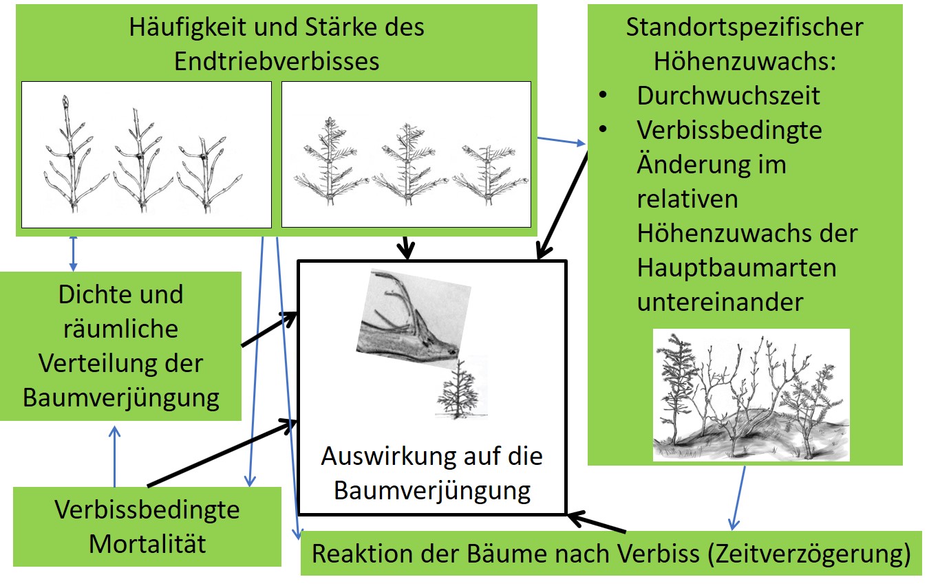
Wildlebende Tiere - besonders Reh, Gämse und Rothirsche - fressen die Triebe junger Bäumchen. Wildlebende Huftiere wählen dabei selektiv einzelne Baumarten und die vitalsten Baumindividuen aus und beeinflussen deshalb das Wachstum der Verjüngung je nach Art unterschiedlich. Dies kann zu Verschiebungen im Konkurrenzgefüge der Arten führen und den Etablierungserfolg einzelner Arten verändern.
Die langfristigen Auswirkungen des Verbisses durch wildlebende Huftiere auf die Baumverjüngung können nur objektiv eingeschätzt werden, wenn mehrere Merkmale betrachtet werden; die Verbissintensität (Verbissprozent) alleine genügt nicht. Insbesondere sind Informationen zu den folgenden Merkmalen nötig zur Einschätzung des Wildeinflusses:
- Endtriebverbiss-Stärke und deren Häufigkeit
- Höhenzuwachs der Bäumchen und damit i) zur Durchwuchszeit und ii) zu den verbissbedingten Änderungen im Höhenzuwachs der Baumarten untereinander
- Reaktionsgeschwindigkeit resp. die zeitliche Verzögerung bis zur Neuausbildung eines Endtriebes
- Dichte und räumliche Verteilung der Verjüngung
- Verbissbedingte Mortalität der Bäumchen
Die meisten dieser Merkmale lassen sich leicht erfassen (ausgenommen Mortalität) und sollten deshalb in Zukunft Eingang in Verbissinventuren finden.
Die Methode mit der Vermessung der 2 zum Probeflächenzentrum nächst gelegenen Bäumchen je Baumart und Höhenklasse passt die abzusuchende Fläche an die Verjüngungsdichte an, ermöglicht das Messen der Höhenzuwächse an einer minimalen Anzahl an Bäumchen je Art und erlaubt die Berechnung von Flächenanteilen, Durchwuchszeiten, und verbissbedingten Änderungen im Höhenzuwachs der Baumarten untereinander. Am Beispiel der Pilotstudie 2018 zur Einschätzung des Einflusses von Verbiss durch wildlebende Huftiere auf die Baumverjüngung in zwei Wildräumen des Kantons St. Gallen wird diese 2-Baum-Methode vorgestellt.
Für mehr Informationen zum Thema Verjüngung:
Abschätzung Verbisseinfluss:
Kupferschmid, A.D., Brang, P., Bugmann, H., 2020. Einfluss des Verbisses auf die Verjüngung besser beurteilen.
Resultate Pilotstudien St. Gallen:
Kupferschmid, A.D., Gmür, P., 2020. Verbisseinfluss in der Tannenwaldstufe: Zwei unterschiedliche Beispiele aus dem Kanton St. Gallen. Jagd Natur 1, 12-16.
k-Baum Methode zur Einschätzung des Verbisseinflusses:
Kupferschmid, A.D., Gmür, P.A., 2020. Methoden zur Einschätzung des Verbisseinflusses: Vergleich der Messungen an den k nächsten Bäumchen mit Zählungen im Probekreis. Schweiz. Z. Forstwes. 171, 69–78.
Film über die Verjüngungsaufnahme:
Andrea, Kupferschmid; Lachat, Thibault (2020). Einfluss des Wildverbisses auf die Verjüngung : ein Tutorial [Film]. Berner Fachhochschule BFH, Hochschule für Agrar-, Forst- und Lebensmittelwissenschaften HAFL; Eidgenössische Forschungsanstalt für Wald, Schnee und Landschaft WSL. https://arbor.bfh.ch/id/eprint/11872
Anita Nussbaumer Mast in European tree species: triggers, inhibitors, and impact on resource dynamics 
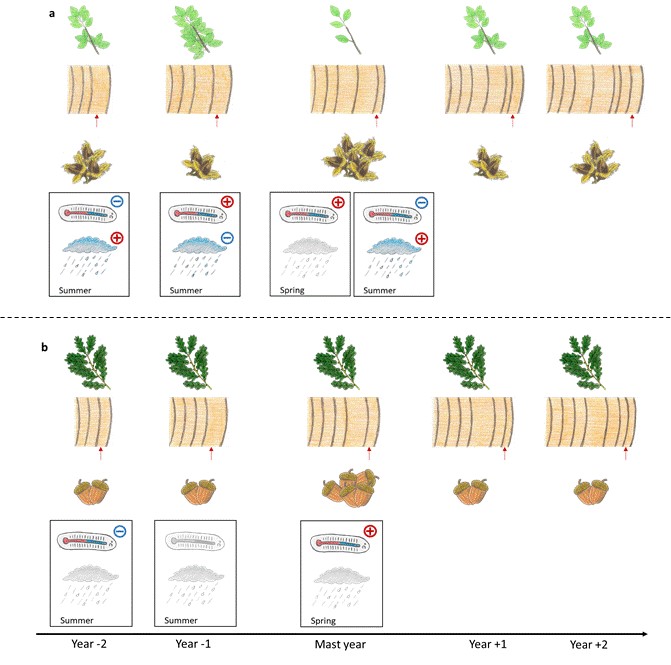
Das Wetter kann ein Auslöser für Jahre mit Massenfruchtbildung (d. h. Mastjahre) sein, aber auch als "ökologisches Veto" fungieren und so zu Fruchtabort, dem frühzeitigen Abbruch der Fruchtentwicklung, führen.
An Standorten des Internationalen Kooperationsprogramms zur Erfassung und Überwachung der Auswirkungen von Luftverunreinigungen auf Wälder (ICP Forests) in ganz Europa werden die Mastjahre der Rotbuche und der Fichte durch unterschiedliche Witterungsbedingungen in den beiden vorangegangenen Sommern ausgelöst, während Stiel- und Traubeneiche nur von günstigen Bedingungen während der Bestäubungsperiode abhängen.
Während der Hitzewelle und der langanhaltenden Trockenheit im Sommer 2018 kam es an zwei von drei LWB-Buchenstandorten in der Schweiz zu Fruchtabort. Wir fanden heraus, dass dies höchstwahrscheinlich ein Mechanismus ist, um Ressourcenverluste zu verhindern, wenn die Umweltbedingungen für die Fruchtbildung ungünstig sind. Darüber hinaus fanden wir Hinweise auf einen grundlegenden zweijährigen Mastzyklus bei der Rotbuche, der durch "Umweltvetos" wie Spätfrost während der Bestäubung oder Hitzewellen und Dürreperioden während der Fruchtentwicklung unterbrochen werden kann. Auf ICP-Forest-Standorten in ganz Europa zeigen Laubbaumarten in Mastjahren eine unterschiedliche Ressourcendynamik. Während in Europa das Stammwachstum (BAI) der Buche in Mastjahren reduziert ist, zeigen Stiel- und Traubeneiche einen leichten Anstieg des BAI.
Für weitere Informationen siehe:
Anita Nussbaumer, Peter Waldner, Vladislav Apuhtin, Fatih Aytar, Sue Benham, Filippo Bussotti, Johannes Eichhorn, Nadine Eickenscheidt, Petr Fabianek, Lutz Falkenried, Stefan Leca, Martti Lindgren, María José Manzano Serrano, Stefan Neagu, Seppo Nevalainen, Jozef Pajtik, Nenad Potočić, Pasi Rautio, Geert Sioen, Vidas Stakënas, Celal Tașdemir, Iben Margrete Thomsen, Volkmar Timmermann, Liisa Ukonmaanaho, Arne Verstraeten, Sören Wulff, Arthur Gessler. 2018. Impact of weather cues and resource dynamics on mast occurrence in the main forest tree species in Europe. Forest Ecology and Management 429: 336-350. doi: 10.1016/j.foreco.2018.07.011
Anita Nussbaumer, Katrin Meusburger, Maria Schmitt, Peter Waldner, Regula Gehrig, Matthias Haeni, Andreas Rigling, Ivano Brunner, Anne Thimonier. 2020. Extreme Sommerhitze und Trockenheit führen bei der Rotbuche zu frühem Fruchtabort. Scientific Reports 363: 10.5334. doi:10.1038/s41598-020-62073-0
Dieser Text wurde automatisch übersetzt.
Florian Zellweger - Forest microclimate dynamics drive plant responses to warming 

Die Klimaerwärmung führt zu einer Verschiebung der Lebensgemeinschaften zugunsten wärmeaffiner Arten (d. h. Thermophilisation). Die Reaktionen der Arten hinken der Klimaerwärmung oft hinterher, aber die Gründe für diese Verzögerungen sind noch weitgehend unbekannt. Hier analysieren wir die Dynamik des Mikroklimas im Unterholz europäischer Wälder über mehrere Jahrzehnte und zeigen, dass die Thermophilisierung und die klimatische Verzögerung in Waldpflanzengemeinschaften in erster Linie vom Mikroklima gesteuert werden. Eine zunehmende Bedeckung mit Bäumen verringert die Erwärmung innerhalb der Wälder, aber der Verlust der Bedeckung führt zu einer erhöhten lokalen Erwärmung, die das Ungleichgewicht zwischen den Reaktionen der Gemeinschaft und dem Klimawandel verschärft. Die Wechselwirkungen zwischen Pflanzen und Mikroklima sind der Schlüssel zum Verständnis der Reaktion der biologischen Vielfalt und der Funktionsweise der Wälder auf Klima- und Landnutzungsänderungen.
Für weitere Informationen siehe:
Zellweger, F., De Frenne, P., Lenoir, J., Vangansbeke, P., Verheyen, K., Bernhardt-Römermann, M., … Coomes, D. (2020). Forest microclimate dynamics drive plant responses to warming. Science, 368(6492), 772-775. https://doi.org/10.1126/science.aba6880
Dieser Text wurde automatisch übersetzt.
Christian Temperli - Decision support systems (DSS) for forestry by the the research unit forest resources and management 
Der Forschungsbereich Forstliche Ressourcen und Management entwickelt und unterhält eine breite Palette von Entscheidungsunterstützungssystemen (DSS) für die Forstwirtschaft. Die hier vorgestellte Website gibt einen Überblick. Eine nachhaltige Waldbewirtschaftung zielt darauf ab, die gesellschaftlichen, ökologischen und wirtschaftlichen Interessen an der Nutzung der Waldressourcen in Einklang zu bringen. Die Komplexität der Waldsysteme, die langfristigen Auswirkungen von Bewirtschaftungsmaßnahmen und die ungewissen Auswirkungen des Klimawandels, wirtschaftliche Trends sowie Veränderungen in der Nachfrage nach Waldressourcen erschweren jedoch die Suche nach geeigneten Bewirtschaftungsentscheidungen. Sogenannte Entscheidungsunterstützungssysteme (DSS) können die Entscheidungsfindung in komplizierten forstlichen Planungssituationen unterstützen. Ein DSS ist ein interaktives, meist computergestütztes Werkzeug, das Entscheidungsträgern bei der Lösung komplexer Probleme hilft. Die WSL-Forschungsstelle FOREMA stellt eine Reihe von Softwarepaketen zur Verfügung, die die Entscheidungsfindung in verschiedenen Bereichen der schweizerischen Forstwirtschaft unterstützen. Einige der vorgestellten DSS verfügen über eine ausgereifte grafische Benutzeroberfläche und sind grösstenteils selbsterklärend, während andere aus Tabellenkalkulationen, R-Paketen oder Java-Code bestehen und einen höheren Schulungsaufwand erfordern. Dementsprechend variieren der Anwendungsbereich und die anvisierte Benutzergruppe von DSS zu DSS. Einige sind für die Unterstützung von Entscheidungen in der betrieblichen Forstwirtschaft gedacht, während andere besser für Forschungsanwendungen geeignet sind.
Dieser Text wurde automatisch übersetzt.
Janine Schweier - Sustainable Forestry in a climate change affected environment 
Die Förster müssen sich mit verschiedenen Herausforderungen auseinandersetzen, die durch den Klimawandel verursacht werden und direkte Auswirkungen auf die Waldbewirtschaftung haben. So führen beispielsweise mehr Niederschläge im Winter und weniger Frostperioden zu einem verstärkten Einsatz von Seilbahnsystemen in den Niederungen für die Holzernte; und ein hoher Anteil an unvorhersehbarer Holznutzung erfordert eine stärkere Konzentration auf organisatorische Tätigkeiten. Die derzeitigen waldbaulichen Bewirtschaftungsstrategien reagieren auf die durch den Klimawandel verursachten Veränderungen und zielen darauf ab, die Widerstandsfähigkeit und Belastbarkeit der Wälder zu erhöhen. Sie führen aber auch zu Herausforderungen: Mischwälder können zum Beispiel kaum mit vollmechanisierten Systemen beerntet werden. Ein weiterer Aspekt von zunehmender Bedeutung ist die Frage, welche Ökosystemleistungen erbracht werden sollen und als wertvolles Produkt auf den Markt gebracht werden können. Eine moderne Forstwirtschaft muss sich diesen Herausforderungen stellen und sollte dabei wirtschaftliche, ökologische und gesellschaftliche Dimensionen berücksichtigen, um eine nachhaltige Waldbewirtschaftung zu unterstützen, die von den verschiedenen Interessengruppen akzeptiert wird und somit erfolgreich ist.
Dieser Text wurde automatisch übersetzt.
Alex Massey - Design-based improvements in change estimation in the Swiss National Forest Inventory through integration with external monitoring networks and sources 
Die modellgestützte Schätzung ist ein gängiges Verfahren zur Verbesserung der Genauigkeit von Schätzungen bei Waldinventuren, da sie unabhängig von Modellfehlern unverzerrte Ergebnisse liefert. Da sie am häufigsten für die Schätzung des Holzvolumens in irgendeiner Form verwendet wird, bestehen die Hilfsinformationen in der Regel aus Fernerkundungsdaten, die entweder auf Satellitenbildern oder einem Vegetationshöhenmodell (VHM) basieren. Da jedoch immer mehr potenzielle Quellen für Zusatzinformationen zur Verfügung stehen, stellt sich die zentrale Frage, welche Informationsquellen sich im modellgestützten Rahmen am besten ergänzen. Hier wird eine Fallstudie im Zusammenhang mit der Schätzung von Veränderungen und nicht der Schätzung des Volumens vorgestellt. Eine Vielzahl potenzieller Hilfsvariablen wird einer von fünf Kategorien zugeordnet: räumlich, satellitengestützt, topografisch, VHM und mechanistisch. Alle Kombinationen von Kategorien durchlaufen dann einen Algorithmus zur Variablenauswahl, und ihre Genauigkeit wird bewertet. Es wird auch eine neue Technik vorgestellt, mit der Plots aus externen Quellen direkt in das Schätzverfahren integriert werden können. Die wichtigsten Ergebnisse waren, dass jede einzelne Kategorie eine mäßige Steigerung der Genauigkeit bewirken kann und die höchste Steigerung bei der Einbeziehung aller Kategorien zusammen auftritt. Die Fernerkundung aus Satellitenbildern oder das VHM zeigten jedoch das größte Potenzial zur Verringerung der Varianz.
Dieser Text wurde automatisch übersetzt.
David Forrester - Linking forest growth with stand structure: tree size inequality, tree growth or resource partitioning and the asymmetry of competition 

Die Bestandesstruktur kann das Waldwachstum und andere Prozesse wie den Wasserhaushalt, die Kohlenstoffverteilung, den Nährstoffkreislauf und die Lichtdynamik stark beeinflussen. Einzelne Strukturvariablen können jedoch positiv oder negativ mit dem Wachstum korreliert sein. Dies gilt für Variablen wie die Größenungleichheit und solche, die die Ressourcenverteilung beschreiben, wie der Grad der symmetrischen/asymmetrischen Konkurrenz und die Wachstumsdominanz. Die gegensätzlichen Korrelationen zwischen Wachstum und Struktur scheinen sich anzunähern, wenn sie anhand eines einfachen Rahmens untersucht werden, bei dem das Wachstum der Bestände eine Funktion von drei Variablen ist und nicht von einer der Variablen allein: Bestandsdichte, Größenverteilung und Größen-Wachstumsbeziehungen. Die Größenverteilungen quantifizieren, wie die Bestandsdichte auf die verschiedenen Größen verteilt ist, während die Größen-Wachstums-Beziehungen quantifizieren, wie das Wachstum auf die verschiedenen Größen aufgeteilt ist. Die Größenungleichheit ist möglicherweise nicht oft eine nützliche Erklärungsvariable; stattdessen scheint sie manchmal mit dem Wachstum zu korrelieren, weil sie mit anderen Variablen, die das Wachstum beeinflussen, korreliert sein kann. Der einfache Rahmen aus drei Variablen könnte verwendet werden, um die Auswirkungen von Struktur und Funktion zu trennen, wenn Mischwälder und monospezifische Wälder verglichen werden, sowie um waldbauliche Eingriffe zu entwerfen oder um festzustellen, ob frühere Bewirtschaftungsmaßnahmen ihre Ziele erreicht haben.
Dieser Text wurde automatisch übersetzt.
Rita Ghosh - On automatic detection of locations with high/low average values 
Im Zusammenhang mit der Regressionsmodellierung erörtern wir einige Ideen zur Erkennung von Punkten im Raum und/oder in der Zeit, an denen eine bestimmte Ableitung der Regressionsfunktion im Vergleich zu einem bestimmten Schwellenwert zu hoch oder zu niedrig ist. Die gewählte Ordnung (j) der Ableitung hängt von der jeweiligen Fragestellung ab. Nimmt man beispielsweise bei Zeitreihendaten j=1, so kann man Zeitpunkte erkennen, bei denen die Änderungsgeschwindigkeit über einem bestimmten Schwellenwert liegt, d. h. Punkte mit schnellen Änderungen. Bei räumlichen Daten können wir daran interessiert sein, Orte zu finden, an denen der Mittelwert (j=0) selbst hoch ist, z. B. Standorte von Waldbeständen mit einem hohen mittleren DBH-Wert. In Anbetracht der großen räumlichen und zeitlichen Skalen, mit denen wir es zu tun haben, treffen wir flexible Annahmen über unser Regressionsmodell und verwenden die Kernelglättung für die Kurven-/Oberflächenschätzung. Wir werden die wichtigsten Ideen erörtern und dabei Prinzipien und Berechnungsprobleme hervorheben, zusammen mit einigen Datenbeispielen. Dieser Vortrag basiert teilweise auf gemeinsamer Arbeit mit Gabi Moser (Gast, Statistics Lab) sowie auf der Zusammenarbeit mit mehreren anderen Kollegen. Verweise auf veröffentlichte und laufende Forschungsarbeiten werden während des Vortrags erwähnt.
Dieser Text wurde automatisch übersetzt.
Meinrad Abegg - Characterisation of tree volume for the Swiss NFI using terrestrial laser scanning 
Die rasche methodische und technologische Entwicklung von tragbaren terrestrischen Laserscannern (TLS) und ihre Anwendung im Rahmen von Waldinventuren in den letzten Jahren führen zu der Frage, ob sie für nationale Waldinventuren (NWI) eingesetzt werden können, um deren Aussagekraft zu verbessern, insbesondere dort, wo direkte Messungen sehr teuer oder unmöglich sind. Vor allem das Baumvolumen, eine der wichtigsten Baumvariablen in einer nationalen Waldinventur, kann nicht direkt gemessen werden. Bislang musste die Volumenschätzung auf allometrische Modelle zurückgreifen. TLS hat das Potenzial, die Probleme allometrischer Modelle, wie mangelnde Repräsentativität oder Aktualität, zu überwinden, indem das Baumvolumen direkt auf Probeflächen gemessen wird. Allerdings ist noch wenig über die Wechselwirkung zwischen TLS-Feldprotokollen, TLS-Geräten, Baum- und Bestandeseigenschaften auf die Qualität der TLS-Messungen bekannt.
Um die Anwendbarkeit von TLS zu bewerten, wird ein NFI, das 3D-Inhaltserstellungsprogramm Blender, verwendet, um TLS in bewaldeten Umgebungen zu simulieren und die folgenden Fragen zu klären: Welches sind die geeigneten Platzierungsmuster der Scanner auf den Probeflächen für eine optimale TLS-Abdeckung in Wäldern? Welche Eigenschaften haben drei moderne TLS-Geräte in Bezug auf die Auslösesignale und wie können sie in eine Simulationsumgebung integriert werden? Welchen Einfluss haben die Signalauslösung und der Laserstrahldurchmesser auf die Qualität der TLS-Punktwolken in Waldgebieten? Und welche Probleme treten bei der Schätzung des Baumvolumens mit TLS auf?
Dieser Text wurde automatisch übersetzt.
Jeanne Portier - ‘Silent reserves’- A hidden treasure in National Forest Inventories 

In einem Europa, das durch jahrhundertelange Forstwirtschaft geprägt ist, ist die Charakterisierung, das Verständnis und die Modellierung natürlicher Wälder eine große Herausforderung. Zusätzlich zu Waldreservaten, die kaum vergleichbare Fallstudien darstellen können, können nationale Waldinventare (NFI) große nationale Datensätze mit einer wertvollen Repräsentativität liefern, da sie aus systematisch verteilten Flächen mit einem variablen Zeitraum seit dem letzten Bewirtschaftungseingriff bestehen. Wir definieren "stille Reserven" als NFI-Flächen, die seit mindestens 50 Jahren frei von menschlichem Einfluss sind. Wir schlagen vor, "stille Reservate" für die Durchführung groß angelegter Studien über naturnahe Wälder zu nutzen und dieses originelle Konzept in der Schweiz zu testen. Wir charakterisieren die kompositorischen und strukturellen Eigenschaften von stillen Reservaten und vergleichen sie mit denen von bewirtschafteten Wäldern. Als Beispiel für eine wissenschaftliche Anwendung analysieren wir die Faktoren auf Baum- und Bestandesebene, die die Baumsterblichkeit in "stillen Reservaten" beeinflussen.
11,2 % der NFI-Flächen in der Schweiz erfüllten die Kriterien für "stille Reservate", vor allem in den Alpen und den Südalpen, wo die Straßenerreichbarkeit für Forstbetriebe geringer ist. Stille Reservate" wiesen eine höhere Natürlichkeit als bewirtschaftete Wälder auf, da sie einen höheren Anteil an Laubbäumen und eine etwas höhere Sterblichkeitsrate als bewirtschaftete Wälder aufwiesen, obwohl die Durchmesserverteilung in beiden Waldtypen ähnlich war. Diese Ergebnisse deuten darauf hin, dass 50 Jahre ohne Bewirtschaftung möglicherweise nicht ausreichen, um die Wälder vollständig von den Auswirkungen der früheren Bewirtschaftung zu befreien, und dass dieser Schwellenwert
Dieser Text wurde automatisch übersetzt.
Ionuț Iosifescu-Enescu - Open Science in Environmental Data Publication - An EnviDat Perspective 

Die wissenschaftliche Gemeinschaft steht derzeit vor einer "Krise der Reproduzierbarkeit". Methoden oder Computercode, die nicht transparent zur Verfügung gestellt werden, fehlende Daten und unvollständige Metadaten sind als Hauptfaktoren für nicht reproduzierbare Ergebnisse erkannt worden und behindern die offene Wissenschaft, auch im Bereich der Erd- und Umweltforschung. Erfreulicherweise sind jedoch weltweit Aktivitäten im Gange, um dieses Problem anzugehen. Die WSL zum Beispiel investiert in die Entwicklung von EnviDat, einem institutionellen Umweltdatenportal und -speicher. EnviDat ist eine Plattform, um kuratierte, qualitätsgeprüfte und wiederverwendbare Forschungsdaten gemäss der WSL-Datenpolitik zugänglich zu machen. EnviDat stellt den Forschenden die technischen Mittel zur Verfügung, um Forschungsdatensätze mit formalen Metadaten zu veröffentlichen und zu dokumentieren, begleitet von korrekten Zitierangaben und Digital Object Identifiers (DOIs). Darüber hinaus ermutigt EnviDat die Forscher, die Datenveröffentlichungen durch Beschreibungen der Forschungsmethoden sowie durch offenen Code unter Verwendung von Juypter Notebooks oder Singularity Containern zu ergänzen. Ein Proof of Concept für offenen Code und Software wurde in Zusammenarbeit mit Mitgliedern der Forschungseinheit FOREMA (M. Fraefel, L. Bont) getestet. Und schliesslich sind dank der Zusammenarbeit mit der WSL-IT sowohl Juypter Notebooks als auch Singularity-Container für den Einsatz in Hyperion, dem Linux-Cluster der WSL für Hochleistungsrechner (HPC), verfügbar. Open Science umfasst viele weitere Aspekte, und es würde den Rahmen von En
Dieser Text wurde automatisch übersetzt.
Marco Ferretti - Defoliation re-considered 
Die europäischen Wälder werden seit den 1980er Jahren überwacht, um ihren Zustand als Reaktion auf abiotische und biotische Einflüsse zu bewerten. Das Hauptmerkmal, das bewertet wird, ist die Abweichung der Laubdichte in den Baumkronen im Vergleich zu einem bestimmten Referenzwert, bei dem von einer vollständigen Belaubung ausgegangen wird. Eine solche Abweichung wird fast allgemein (und fälschlicherweise) als "Entlaubung" bezeichnet und ist Gegenstand einer Reihe von Kritikpunkten, die auf Bedenken hinsichtlich der Datenqualität und der Beziehung zu aussagekräftigen Bewertungsendpunkten (z. B. Wachstum) zurückzuführen sind.
Ich werde kurz Fallstudien aus Frankreich, dem Trentino (Italien) und der Schweiz vorstellen, um zu zeigen, dass die Kronendichte - abgesehen von der berechtigten Kritik - Regelmäßigkeiten in Bezug auf das Wachstum und die Reaktion auf klimatische Einflüsse über Arten und Regionen hinweg aufweisen kann. Dies könnte interessante Perspektiven für ein besseres Verständnis der Dynamik des Waldzustands und der Rückkopplungen auf den Klimawandel eröffnen.
Dieser Text wurde automatisch übersetzt.
Jürgen Zell - Modeling ingrowth for empirical forest prediction systems 

Eine genaue und repräsentative Vorhersage des Zuwachses ist für die Modellierung der Waldentwicklung unerlässlich. Neben der Anzahl der eingewachsenen Bäume sind auch die grundlegenden Baummerkmale Durchmesser und Baumart von Bedeutung. In dieser Studie wurden diese drei Merkmale anhand von Daten des Schweizerischen Landesforstinventars (LFI) modelliert. Die Studie deckte große Gradienten von Bestandsbedingungen und Klimavariablen ab, so dass sich die Modelle zur Vorhersage des Zuwachses unter dem Klimawandel eignen. Da die Anzahl der eingewachsenen Bäume pro Parzelle mehr Nullen enthielt, als für eine Poisson-Verteilung zu erwarten ist, verwendeten wir drei alternative Wahrscheinlichkeitsverteilungen: die null-inflationäre Poisson-Verteilung (ZIP), die negative Binomialverteilung (NB) und die null-inflationäre negative Binomialverteilung (ZINB). Modelle mit jeder der drei Varianten wurden mit und ohne zufällige Effekte angepasst, was zu sechs verschiedenen Modelltypen führte. Die Modellauswahl erfolgte rückwärts anhand des BIC-Kriteriums. Von den endgültigen Modellen zeigte ZIP die beste Vorhersage der unabhängig beobachteten Anzahl eingewachsener Bäume. Unsere Ergebnisse deuten darauf hin, dass die Anzahl der eingewachsenen Bäume stark vom Entwicklungsstadium der Wälder und von der Grundfläche der Bestände abhängt, während Temperatur und Niederschlag, Stickstoffdeposition und Wasserhaltevermögen jeweils einen geringeren, aber immer noch signifikanten und plausiblen Einfluss haben. Zur Beschreibung der Wahrscheinlichkeitsverteilung des Durchmessers der eingewachsenen Bäume wurde die Weibull-Funktion verwendet, und die Parameter wurden mit Hilfe des Likelihood-Ansatzes geschätzt. Th
Dieser Text wurde automatisch übersetzt.