Christian Temperli (Mathys, A.S., Bottero, A., Stadelmann, G., Thürig, E., Ferretti, M.) - Presenting a Climate-Smart Forestry evaluation framework based on National Forest Inventories 
Climate-smart forestry (CSF) has gained increasing attention in recent years. Yet, a framework to assess the three pillars of CSF, in terms of mitigation and adaptation to climate change and ecosystem service (ES) provision based on national forest inventory (NFI) data is currently lacking. In this study, we present an assessment framework of CSF based on forest indicators derived from NFI. To quantify the three pillars of CSF we defined 1) mitigation based on the forest carbon stock, 2) adaptation using biodiversity and susceptibility to disturbances caused by storm and bark beetles and 3) ES provision with timber production and protection against avalanches and rockfall. We demonstrate the application of this framework using Swiss NFI data and projections of future forest development under four different management scenarios. Our results show that, in general, the carbon stock is increasing at the national scale when current management practices are maintained. Increases are especially pronounced in the Jura and Southern Alps regions. Trade-offs occur between enhancing mitigation and adaption, and the sustainable provision of ES such as timber production. Scenarios with increased harvesting intensities lead to a higher timber supply in the short-term, while decreasing the carbon stock, biodiversity-related old growth indicators and the protective function of forests. The indicator framework presented in this study provides a first methodological approach that can support policy making to balance the different forest services in the context of CSF.
Stefan Holm, Janine Schweier - Work in progress: developing a 3-dimensional digital twin of a forest 
We got an impressing introduction in to the on-going work of Stefan Holm and Janine Schweier.
Linus Ender - Using airborne LiDAR data and machine learning to obtain stand structure in Swiss forests 
Understanding and monitoring forest stand data is crucial for sustainable forest management. The Swiss National Forest Inventory (NFI) continuously assesses the status and development of the Swiss forests on more than 6000 plots distributed on a nationwide grid. One of the parameters acquired by the NFI is vertical stand structure. While fundamental in forest planning, it is also known to be a good proxy for habitat diversity, light availability, and recreational potential. However, assessing the vertical structure of forest stands in the field is difficult and requires expert knowledge. Thus, stand structure assessment might be subjected to observer bias. Remote sensing has shown great potential in analysing forest stand structure in recent studies and could be a means to reduce such uncertainties. The Swiss Federal Office of Topography (swisstopo) is currently producing a nationwide airborne laser scanning (ALS) data set of classified point clouds with an average point density of 15 – 20 points/m2. In this work, two possible ways to assess vertical stand structure using ALS and NFI data are presented. The stand structure definition is closely based on the one specified by the Swiss NFI. This allowed the usage of their stand structure assessment as training data for a convolutional neural network and a Random Forest classifier. While testing with independent data, the neural network achieved an accuracy of 0.71 and the Random Forest an accuracy of 0.63. Continued development of these algorithms could improve the results even further. Hence, the discussed methods present a possible pathway to gain stand structure from ALS data on a country wide scale.
Jochen Bihn - Open Access and DORA 

For researchers it becomes increasingly important to publish their work open access. Jochen Bihn from lib4ri gave a thorough overview over the ways to open access publication and could provide useful clues on how to get there.
Stefan Klesse - N-Depend: Is there a “Nitrogen Deposition Penalty” for Forests under Drought? 
Increased carbon sequestration due to Nitrogen (N) deposition has been reported for European forests. Because of higher water demand arising from N-stimulated leaf area and growth, there is growing concern that drought effects are exacerbated in areas with previously (or still) high N-deposition.
In this talk the key results from the WSL-internal project “N-depend” will be presented. One goal of the study was to update the tree growth models implemented in MASSIMO, specifically accounting for interactions between climate and N-deposition (among others) using the entire NFI dataset. Interestingly, the few detected interactions (Ndep * climate) were opposite to expectations. How the spatial and temporal structure of the data hamper the easy assessment and interpretation of N-deposition effects on drought severity, but also opportunities to overcome these hurdles will be discussed.
Gian-Kasper Plattner - The state of the climate: Highlights from the latest IPCC report 

The Assessment Reports of the Intergovernmental Panel on Climate Change (IPCC) have formed the scientific basis for international climate policy for over 30 years now and were the basis for the Paris Climate Agreement of 2015. Shortly before the COP26 climate conference in Glasgow, the IPCC adopted the first part of the 6th Climate Assessment Report on the physical science basis of climate change in August 2021. What does this latest climate report say about the challenges ahead? The presentation provided first-hand insight through an overview of the key messages from the latest IPCC report. It summarized the state of knowledge on the changes observed in the global climate system to date, their causes and possible future developments in the climate system. The presentation highlighted the urgency of taking concrete action to meet the internationally agreed Paris climate targets and to limit the consequences of climate change.
Arun Bose (Brigitte Rohner, Alessandra Bottero, Marco Ferretti, David I. Forrester) - Did the 2018 megadrought change the partitioning of growth between tree sizes and species? A Swiss case-study. 
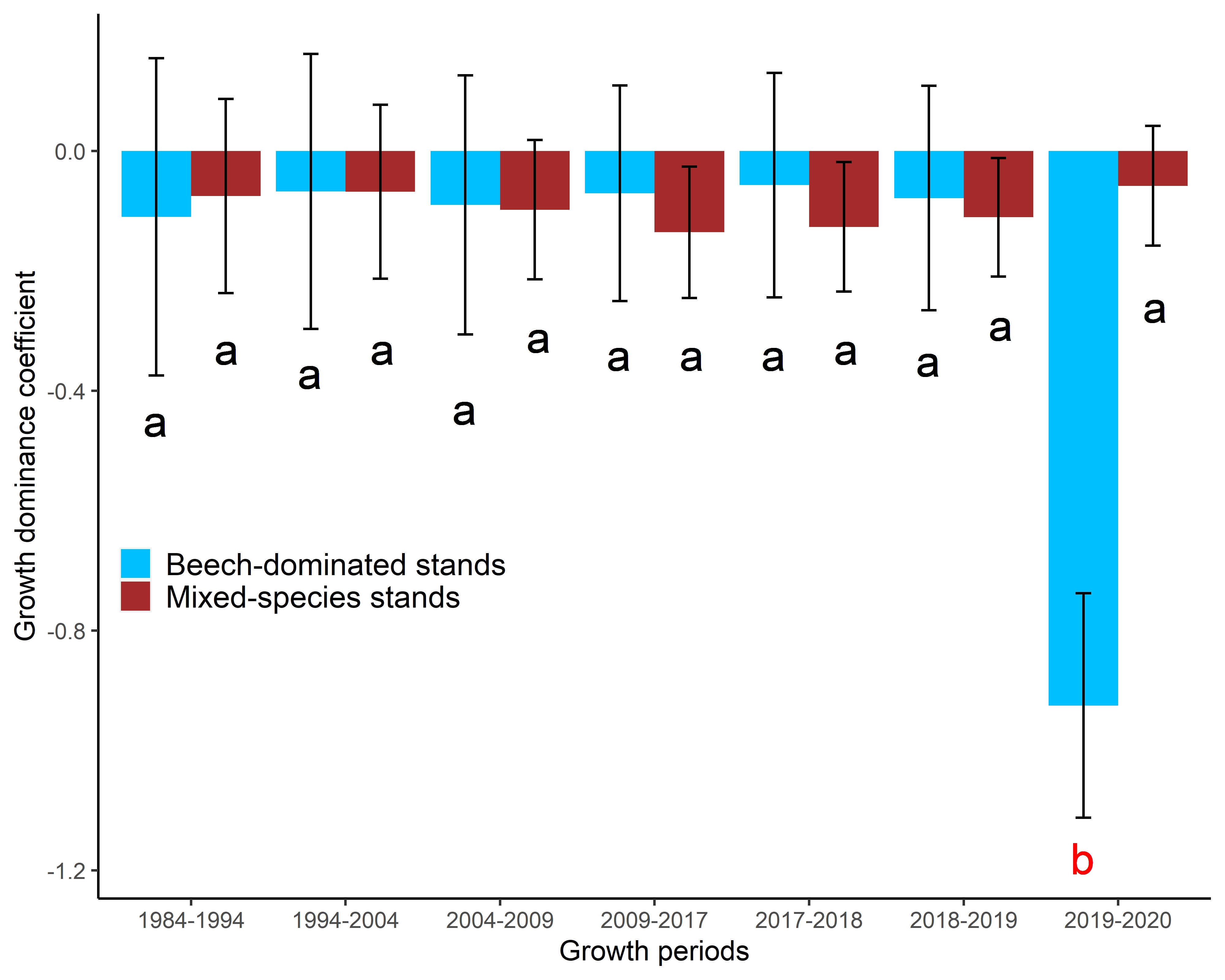
By killing or weakening trees, drought could change the partitioning of growth between tree sizes or species, thereby altering stand structure. Growth partitioning, often quantified as growth dominance coefficient (DC) or the shape of individual tree size vs. growth relationships (SGR), indicates the relative contribution of differently sized trees to the total stand growth. Changes in growth partitioning due to droughts are rarely examined but provide valuable information that links tree- and stand-level responses to droughts. The objective of this study was to test whether DC or SGR can be calculated from small sample sizes of trees, and if so, to use such indices to examine whether the 2018 European megadrought altered the growth partitioning among tree sizes and species. DC, and particularly SGR, were sensitive to sample size, forest types (even-aged and uneven-aged), the target variables (tree diameter, basal area, or stem mass) and the range of tree sizes within the sample. SGR could therefore not be used for our analyses. We found no differences in DC prior to and during the 2018-drought. However, when considering only beech (Fagus sylvatica)-dominated stands, DC was lower during post-drought years than during the 2018-drought. Growth of larger trees, especially beech, was more negatively affected during post-drought years. Therefore, an extreme drought event can indeed alter the growth partitioning within forest stands. The DC indicates such changes in partitioning and hence which trees can be selected for commercial thinning, or released from competition, to minimize potential impacts of droughts.
Lars Waser, Nataliia Rehush (Marius Rüetschi, Achileas Psomas, David Small) - Mapping dominant leaf type based on combined Sentinel-1/-2 data – challenges for mountainous countries 
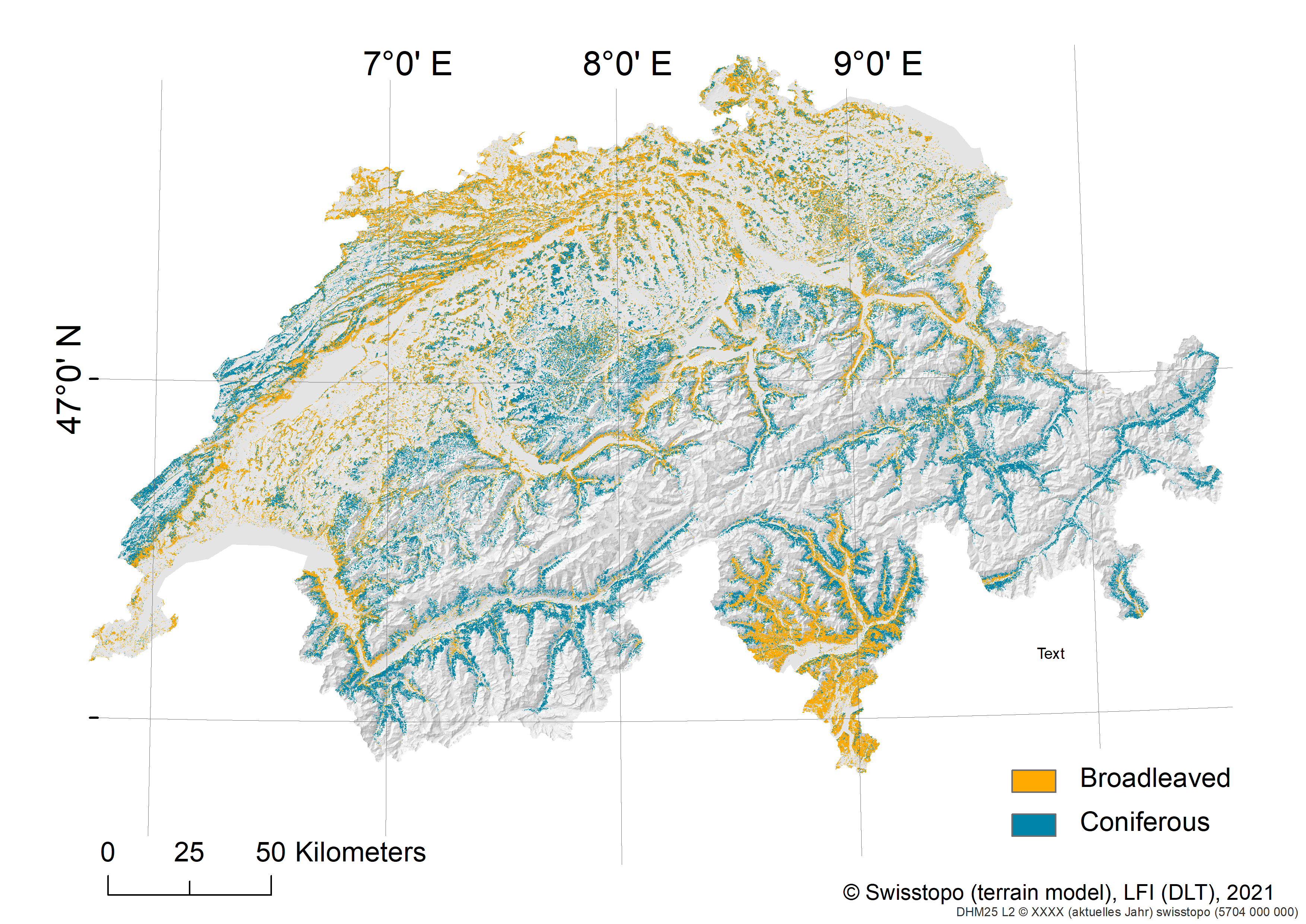
Precise and regularly updated information on the state, change and distribution of forest attributes for entire countries is essential for the forestry sector and beyond. Forest attribute maps such as dominant leaf type (DLT) based on remote sensing techniques, are a reliable and complementary information source to existing National Forest Inventory (NFI) estimates.
In this presentation we show a novel approach to map DLT with the thematic classed broadleaved and coniferous for the whole of Switzerland based on countrywide winter and summer Sentinel-1 (S1) backscatter data, cloud-free summer Sentinel-2 (S2) images, an Airborne Laser Scanning (ALS)-based Digital Terrain Model (DTM) and reference data from aerial image interpretation. Two machine learning approaches, i.e. Random Forest (RF) and deep learning (UNET) for the whole country with three sets of predictor variables were applied. The reference data consists of aerial image interpretation and was split into training, validation and test data sets and was spatially stratified using a 25 km regular grid.
Model accuracies of both RF and UNET were generally highest with Kappa (K) around 0.95 when predictors were included from both S1/S2 and the DTM. While on countrywide level RF and UNET performed overall similarly, substantial differences in model performances, i.e. higher variances and lower accuracies, were found in subareas with northwest to northeast orientations. The combined use of S1/S2 and DTM predictors mitigated these problems related to topography and shadows and was therefore superior to the single use of S1 and DTM or S2 and DTM data. The comparison with independent NFI plot data demonstrated precisions of K around 0.6 in the predictions of DLT and indicated a trend of increasing deviations in mixed forests. A comparison with the Copernicus High Resolution Layer (HRL) DLT 2018 revealed overall higher map accuracies with the exception of pure broadleaved forest. Although, spatial patterns of DTL were overall similar, UNET performed better than RF in areas with a distinct DLT on forest stand level, with the largest differences occurring when only S1 and DTM data was used.
With this study, we go beyond the case study level and meet the requirements of countrywide data sets, in particular regarding repeatability, updating, costs and characteristics of training data sets. The 10 m countrywide DLT maps add complementary and spatially explicit information to the existing NFI estimates and are thus highly relevant for forestry practice and other related fields. The new DLT map is now available as Geobasisdatensatz Waldmischungsgrad LFI 2018 or downloadable (on request by email) in EnviDat as Forest Type NFI 2018.
Daniel Scherrer - Modelling of potential natural forest communities across Switzerland based on NFI-Data: Challenges, opportunities and potential applications 
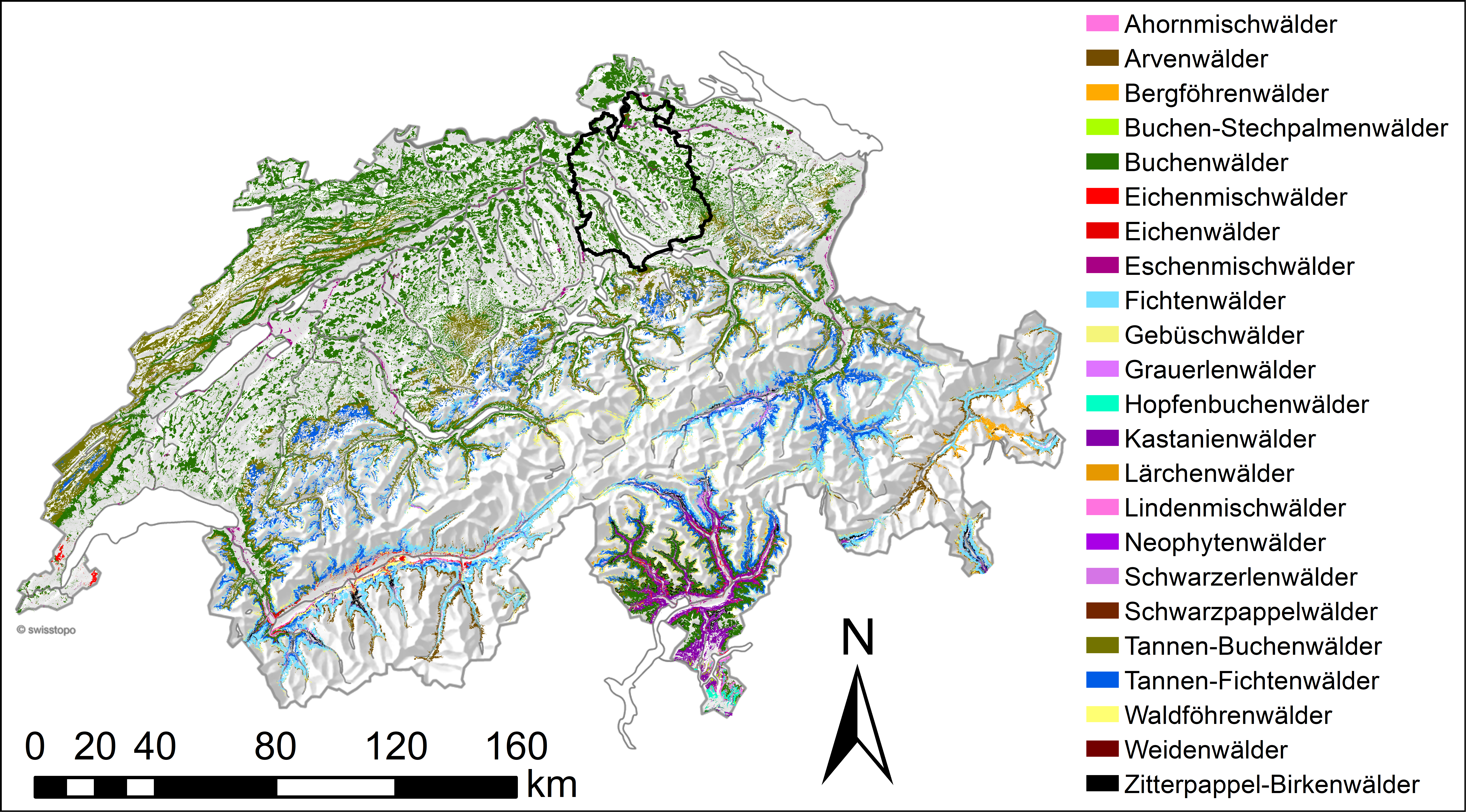
The potential natural forest communities (PNC; Deutsch: Standorttypen) are an expert based classification system for forests representing idealised compositions of tree and understory plant species considered as natural on a given site. The PNCs are determined based on local site conditions (e.g., climate, topography, understory vegetation) and, therefore, can be different from the current tree species composition, as a result, of past or current management decisions (e.g., spruce plantations in the lowland). Based on a recently finished project (NaiS-LFI) mapping the PNCs on all LFI4 sample plots and a large number of environmental predictors the PNCs across Switzerland were modelled under current and future environmental conditions. While the modelling of PNCs is very challenging and has severe limitations the continuous spatial information on the PNCs in combination with LFI data and remote sensing products also offers great potential for several risk assessments. (1) Forest areas where the current tree species composition strongly deviates from the expected composition based on the PNCs can be identified and analysed regarding their vulnerability towards drought, insect outbreaks or other disturbances. (2) Forest areas where the current tree recruitment deviates from the expected future PNC can be identified and the need for management intervention assessed. (3) Forest areas where the PNCs are expected to drastically change under future conditions can be identified and analysed regarding their ability to provide continued ecosystem services (i.e. protection function).
Leo Bont, Laura Ramstein, Fritz Frutig, Janine Schweier - Neue Grundlagen für eine effiziente Seillinienplanung zur Bereitstellung von Ökosystemleistungen 

Wälder erbringen bedeutende Ökosystemleistungen wie Bereitstellung von Holz, Schutz vor Naturgefahren, Erhaltung der Biodiversität, Erholungsraum, Kohlenstoffspeicherung sowie Trinkwasserfilterung und -speicherung. Damit die Wälder diese Dienstleistungen nachhaltig erbringen können, sind waldbauliche Lenkungsmassnahmen erforderlich. Im Schutzwald, muss zur Sicherstellung einer kontinuierlichen Waldverjüngung regelmässig eingegriffen werden. Ausserdem sind viele Pflanzen-, Insekten- und Vogelarten auf gezielte Eingriffe angewiesen, wodurch eine vielfältige Waldstruktur mit einem Nebeneinander sowohl von Altholz- als auch von Pionierwaldphasen geschaffen wird. Auch um einen konstant hohen Zuwachs und damit eine hohe Assimilation von CO2 aus der Luft zu erreichen, sind regelmässige Verjüngungshiebe notwendig. Eine maximale Kohlenstoffsenkenwirkung wird erreicht, wenn das geschlagene Holz für langlebige Holzprodukte verwendet wird, welche den assimilierten Kohlenstoff speichern und energieintensive Baumaterialien wie Stahl und Beton ersetzen. Die Förderung von Baumarten, die an künftige Klimaverhältnisse angepasst sind, sowie die Schaffung von störungsresistenteren und -resilienteren Bestandesstrukturen erfordern ebenfalls entsprechende Lenkungsmassnahmen.
Holzrücken mittels Seilkran ist ein wichtiges Holzernteverfahren in der Schweizer Forstwirtschaft. Etwa die Hälfte der Wälder werden mit seil- und luftgestützten Mitteln erschlossen. Rund ein Viertel der Waldfläche wird mit dem Seilkran bewirtschaftet, wobei konventionelle Seilkräne und Mobilseilkräne in ähnlichem Umfang eingesetzt werden (Brändli et al., 2020).
Im kürzlich abgeschlossenen Projekt «Neue Grundlagen für eine effiziente Seillinienplanung» wurde untersucht, wie wissenschaftliche Erkenntnisse der Seilmechanik, Entwicklungen in der Fernerkundung sowie mathematische Optimierungsalgorithmen in ein modernes Tool für die Seillinienplanung integriert werden können. Die Berechnung der Seillinie wurde an mehreren Fallbeispielen getestet. Die berechneten Durchhänge und Kräfte mittels Kettenlinien-Ansatz (Methode nach Zweifel) lieferten deutlich präzisere Werte als die Ergebnisse der weit verbreiteten Berechnungsmethode nach Pestal. Weiter wurden verschiedene Einzelbaumdetektionsmethoden zur Identifikation von potenziellen Stützenbäumen für Waldflächen im Seilkrangelände verglichen und die besten Methoden mit schweizweit verfügbaren Geodaten getestet. Alle Untersuchungen wurden mit dem QGIS-Plugin Seilaplan durchgeführt, das im Rahmen des Projekts weiterentwickelt und von der Forstpraxis mit grossem Interesse verfolgt und getestet wurde.
Im Referat am Forema Kolloquium wird ein Überblick über das Projekt gegeben, mit dem Schwerpunkt der Validierung der Berechnungen durch Feldmessungen, sowie das QGIS Plugin Seilaplan vorgeführt.
Weitere Informationen zum Thema:
Roman Zweifel - When do trees actually grow? 

Surprising but true: We hardly know when exactly trees grow. Yet it is crucial for understanding tree and forest dynamics whether growth occurs uniformly over days and weeks or lasts for only relatively few hours during a growing season. Here we show that radial growth is mainly timed by air dryness, and trees therefore grow mostly in the second half of the night. This suggests that carbon uptake and carbon consumption are temporally decoupled from growth, and that the growth process is more sensitive to air dryness than carbon uptake.
Further information:
Sandro Bischof, David Hanimann, Isabel Meraner, Lukas Wotruba - Linking the Swiss forest to the world-wide web of data 
Linking the Swiss forest to the world-wide web of data
Linked data (LD) has the potential to be the driver of web 2.0, a web that does not only show us documents about pines, but actually knows what a pine is. Many institutions around the world contribute to the global web of data. The Federal Linked Data Service LINDAS provides a platform to publish and visualize governmental data - the 40 years of NFI data are among the considered major scientific data sources.
We have implemented a pipeline that transforms the NFI result tables currently published as HTML into linked data. These build up a graph of millions of three-part statements such as beech - is_a - tree_species. We demonstrate how linking our graph to other web-resources of LD such as the Swisstopo geometries creates enriched knowledge bases for applications and SPARQL query endpoints.
As statistical background information is often required to comprehensively interpret the NFI result tables, generating congruent and machine-readable output reveals several potential pitfalls. Fine-tuning the data model to a NFI-tailored level of abstraction remains therefore one of the main challenges.
Based on the insights from developing this linked data prototype, a productive version of the dataset can be integrated into the FOEN visualization tool. Not only can handy visualizations be generated with just a few clicks, the interlinkable NFI result data will be available as the most trustworthy source of information on Swiss forests on the internet.